Celorico de Basto
| Celorico de Basto | |||
|---|---|---|---|
| Municipality | |||
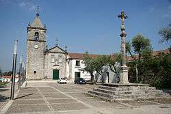 Monastery of St. John Arnóia | |||
| |||
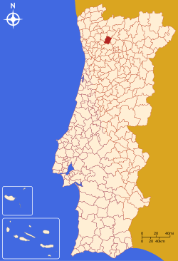 | |||
| Coordinates: 41°23′N 8°00′W / 41.383°N 8.000°WCoordinates: 41°23′N 8°00′W / 41.383°N 8.000°W | |||
| Country |
| ||
| Region | Norte | ||
| Subregion | Tâmega | ||
| Intermunic. comm. | Tâmega e Sousa | ||
| District | Braga | ||
| Parishes | 15 | ||
| Government | |||
| • President | Albertino Mota Silva (PSD) | ||
| Area | |||
| • Total | 181.07 km2 (69.91 sq mi) | ||
| Population (2011[1]) | |||
| • Total | 20,098 | ||
| • Density | 110/km2 (290/sq mi) | ||
| Time zone | WET/WEST (UTC+0/+1) | ||
| Postal code | 4890 | ||
| Website |
www | ||
Celorico de Basto (Portuguese: [sɨloˈɾiku ðɨ ˈβaʃtu] (![]()
The present mayor is Albertino Mota Silva, elected by the Social Democratic Party. The municipal holiday is July 25.
Celorico de Basto has been occupied since ancient times, as witness marks in the most ancient civilisations have left here.
Parishes
Administratively, the municipality is divided into 15 civil parishes (freguesias):[4]
- Agilde
- Arnóia
- Borba de Montanha
- Britelo, Gémeos e Ourilhe
- Caçarilhe e Infesta
- Canedo de e Corgo
- Carvalho e Basto (Santa Tecla)
- Codeçoso
- Fervença
- Moreira do Castelo
- Rego
- Ribas
- São Clemente de Basto
- Vale de Bouro
- Veade, Gagos e Molares
International relations
Celorico de Basto is twinned with:
References
- ↑ Statistics Portugal
- ↑ Instituto Nacional de Estatística
- ↑ Direção-Geral do Território
- ↑ Diário da República. "Law nr. 11-A/2013, page 552 30" (pdf) (in Portuguese). Retrieved 20 July 2014.
- ↑ "Bienvenue au Comité de Jumelage de Houilles". Comité de Jumelage de Houilles (in French). Retrieved 2013-07-16.
External links