Cedar River Flow
| Cedar River Flow | |
|---|---|
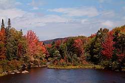 Cedar River Flow in the fall | |
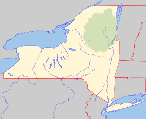 Cedar River Flow Location of Cedar River Flow within New York State  Cedar River Flow Cedar River Flow (the US) | |
| Location | Hamilton County, New York |
| Coordinates | 43°42′31″N 74°28′38″W / 43.70861°N 74.47722°WCoordinates: 43°42′31″N 74°28′38″W / 43.70861°N 74.47722°W |
| Type | Reservoir |
| Primary inflows | Cedar River |
| Primary outflows | Cedar River |
| Surface elevation | 2,100 feet (640 m)[1] |
| Settlements | Indian Lake, New York |
The Cedar River Flow is a remote 640-acre (2.6 km2) shallow lake, created by the Wakely Dam on the Cedar River, where there are a number of campsites accessible via a gravel road, 14 miles (23 km) from Indian Lake or 23 miles (37 km) from Inlet. More campsites are accessible via canoe, around the Flow. It lies on the border between the Moose River Plains Wild Forest and the West Canada Lake Wilderness Area. Fish species present in the lake include brook trout, brown trout, and white sucker. There is a carry down boat access via a trail from the Northville-Lake Placid Trail on the west shore. No motors are allowed on the Cedar River Flow.
References
- ↑ "Cedar River Flow". Geographic Names Information System. United States Geological Survey. Retrieved 2017-12-23.
This article is issued from
Wikipedia.
The text is licensed under Creative Commons - Attribution - Sharealike.
Additional terms may apply for the media files.