Cedar Point, Virginia
| Cedar Point, Virginia | |
|---|---|
| Unincorporated community | |
 Cedar Point  Cedar Point | |
| Coordinates: 37°41′31″N 77°54′34″W / 37.69194°N 77.90944°WCoordinates: 37°41′31″N 77°54′34″W / 37.69194°N 77.90944°W | |
| Country | United States |
| State | Virginia |
| County | Goochland |
| Elevation | 154 ft (47 m) |
| Time zone | UTC-5 (Eastern (EST)) |
| • Summer (DST) | UTC-4 (EDT) |
| Area code(s) | 804 |
| GNIS feature ID | 1494869[1] |
Cedar Point is an unincorporated community in Goochland County, Virginia, United States. Cedar Point is located on the James River 1.4 miles (2.3 km) west of Goochland. The Lock-Keeper's House, which is listed on the National Register of Historic Places, is located near Cedar Point.[2]
References
- ↑ "Cedar Point". Geographic Names Information System. United States Geological Survey.
- ↑ National Park Service (2010-07-09). "National Register Information System". National Register of Historic Places. National Park Service.
Municipalities and communities of Goochland County, Virginia, United States | ||
|---|---|---|
| CDP | 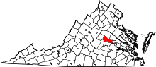 | |
| Unincorporated communities | ||
This article is issued from
Wikipedia.
The text is licensed under Creative Commons - Attribution - Sharealike.
Additional terms may apply for the media files.