Caw (hill)
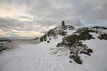
Summit trig point, with Black Combe on left horizon
Caw is a hill in Cumbria, England, near the village of Seathwaite above the Duddon Valley, reaching 1,735 feet (529 m) and having a trig point at the summit (OS grid SD231945). It is the subject of a chapter of Wainwright's book The Outlying Fells of Lakeland.[1] His anticlockwise route from Seathwaite returns over Pikes at 1,520 feet (460 m) and Green Pikes at 1,350 feet (410 m).
References
- ↑ Wainwright, A. (1974). "Caw". The Outlying Fells of Lakeland. Kendal: Westmorland Gazette. pp. 120–125.
This article is issued from
Wikipedia.
The text is licensed under Creative Commons - Attribution - Sharealike.
Additional terms may apply for the media files.