Caullaraju
| Caullaraju | |
|---|---|
| Jeulla Rajo, Jenhuaracra | |
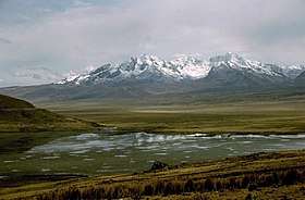 Caullaraju and Lake Conococha | |
| Highest point | |
| Elevation | 5,682 m (18,642 ft) |
| Coordinates | 9°57′45″S 77°15′36″W / 9.96250°S 77.26000°WCoordinates: 9°57′45″S 77°15′36″W / 9.96250°S 77.26000°W |
| Geography | |
 Caullaraju Peru | |
| Location | Peru, Ancash Region |
| Parent range | Andes, Cordillera Blanca |
| Climbing | |
| First ascent | -1962 via N. face: W. side-1966: N.E. ridge-1977[1] |
Caullaraju[2][3][4][5] or Jeulla Rajo[6][7] (possibly from Quechua qiwlla gull, rahu snow, ice, mountain with snow,[8] "snow-covered gull mountain") is a mountain in the Cordillera Blanca in the Andes of Peru, about 5,682 m (18,642 ft) high.[3][7] It is located in the Ancash Region, Recuay Province.[6] In the IGN-Peru map, the highest peak is reported to be named Jenhuaracra.[3]
See also
References
- ↑ Jilla Neate, Mountaineering in the Andes, 1994
- ↑ "Nevado Caullaraju-Pico Central - Peakbagger.com". www.peakbagger.com. Retrieved 2016-06-19.
- 1 2 3 Alpenvereinskarte 0/3b. Cordillera Blanca Süd (Peru). 1:100 000. Oesterreichischer Alpenverein. 2005. ISBN 3-937530-05-3.
- ↑ Biggar, John (2005). The Andes: A Guide for Climbers. Andes. p. 92. ISBN 9780953608720.
- ↑ Díaz, Felipe (2008–2009). Carta Turística. Cordilleras Blanca, Negra, Huayhuash y Callejón de Huaylas.
- 1 2 "Mapa UGEL Recuay" (PDF). Mapas DRE y UGEL. ESCALE - Ministerio de Educación - Perú. 2010. Retrieved 2016-06-18.
- 1 2 Peru 1:100 000, Recuay (20-i). IGN (Instituto Geográfico Nacional - Perú).
- ↑ babylon.com
This article is issued from
Wikipedia.
The text is licensed under Creative Commons - Attribution - Sharealike.
Additional terms may apply for the media files.