Catacol Bay
| Catacol Bay | |
|---|---|
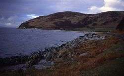 Shoreline of Catacol bay looking north. | |
| Location | Isle of Arran, Argyll and Bute Scotland |
| Coordinates | 55°41′26.4012″N 5°19′57.0864″W / 55.690667000°N 5.332524000°WCoordinates: 55°41′26.4012″N 5°19′57.0864″W / 55.690667000°N 5.332524000°W |
| River sources | Glen Catacol |
| Ocean/sea sources | Kilbrannan Sound |
| Basin countries | Scotland |
| Max. length | 1.8 km (1.1 mi) |
| Max. width | 0.45 km (0.28 mi) |
| Settlements | Catacol |
Catacol Bay (Scottish Gaelic: Catagal bhàigh) is a small shallow-curved tidal, 310° facing, rocky coastal embayment located on the northwest tip of the Isle of Arran in the Firth of Clyde, within the council area of Argyll and Bute in Scotland.[1]
Geography
The bay faces the Kilbrannan Sound a marine water body that separates the Kintyre Peninsula from the Isle of Arran and offers excellent views of the peninsula. Kilbrannan Sound is the western arm of the Firth of Clyde
Overlooking the bay to the south is the hill Meall nan Damh at 570 metres, which lies above Glen Catacol, and is the northernmost of the Pirnmill Hills. The most picturesque of lochs on Arran is Loch Corrie between Meall nan Damh and the hill of Meal Biorach at 551 metres.[2] South by south east of the bay lies the smaller hill of Meall Mòr at 496 metres.
Behind the bay is Glen Catacol, that is a very steep sided valley made up of granite and basalt, with the Glen Catacol river running down the valley[3], where it is met by the small stream of Gleann Diohan at the base of the hill Meall nan Leac Sleamhuinn at 272 metres.
Directly to the north of the bay at 1 mile distance, is the sea loch, Loch Ranza. The closest bay south of Catacol bay is Machrie Bay 11.5 miles directly south of Catacol.
Settlements
The Norse name for the tiny village of Catacol itself is The gully of the cat [4]. The village of Catacol has a row of low white terraced cottages called the 'Twelve Apostles'.[5] They were built to house those people cleared from the surrounding countryside, when much of the interior of the island was set aside for deer. The theory was these former farmers would turn to fishing, and with this in mind, each of the twelve cottages had a differently shaped first floor window. This would allow the woman of the house to signal by placing a candle in the window to her husband out while he was out fishing in the Firth of Clyde. The husband would know who was being signaled by the shape of the window. In reality, most of the dispossessed moved away to other parts of the island in protest against their eviction.
Further along the A841 to the north lies the small Catacol Bay Hotel. directly to the north east of the bay Lochranza, about 1 miles along the A841 road. Almost 5 miles south west of Catacol along the A841 road, lies the former industrial village and now tourist village of Pirnmill.
Features
The Fairy Dell is an ethereal spot where Fairy folk are supposed to dance, is located above Lochranza.[6]
Gallery
 Glen Catacol with Glen Catacol river.
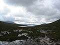 Loch Tanna, seen from Glen Catacol.
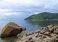 Catacol Bay on a beautiful day.
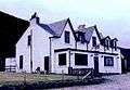 Catacol Bay Hotel
 Sunset over Catacol Bay.
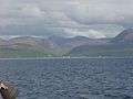 Catacol Bay showing the Glen Catacol, taken from the Lochranza-Claonig Ferry.
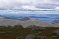 Meall nam Damh
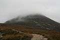 Northern Slopes of Meall Biorach. Looking up from the Coire Fhionn Lochan path.
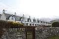 Twelve apostles.
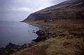 Fairy Dell mouth A lonely house sits on the raised beach at the end of Fairy Dell. Behind, the hillside seems to be tumbling into the sea.
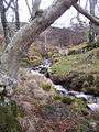 Winter in the Fairy Dell. The Fairy Dell is a small wooded area next to a boathouse on the northernmost tip of Arran. It is sheltered in a valley in which the burn Allt Mòr runs.
References
- ↑ Paddy Dillon (28 January 2016). Walking on Arran. Cicerone Press. p. 242. ISBN 978-1-78362-280-1.
- ↑ Peter MacNair (29 November 2012). Argyllshire and Buteshire. Cambridge University Press. p. 116. ISBN 978-1-107-65752-6. Retrieved 6 June 2017.
- ↑ The Scots Magazine and Edinburgh Literary Miscellany. Archibald Constable & Company. 1808. p. 22. Retrieved 6 June 2017.
- ↑ Walk the Arran Coastal Way. Walkguides. p. 7. GGKEY:KK89YW82519.
- ↑ Sawyers, June Skinner. Maverick Guide to Scotland. Pelican Publishing. p. 396. ISBN 978-1-4556-0866-9.
- ↑ Mawson, Emily Rose (29 May 2017). "Secret Wilderness - Fairy Dell, Isle of Arran". Wanderlust. Wanderlust Publications Ltd. Retrieved 6 June 2017.