Casupá
| Casupá | |
|---|---|
| Town | |
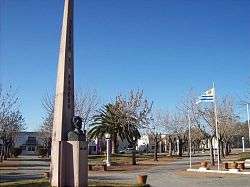 The main square of Casupá | |
 Casupá Location in Uruguay | |
| Coordinates: 34°2′0″S 55°39′0″W / 34.03333°S 55.65000°WCoordinates: 34°2′0″S 55°39′0″W / 34.03333°S 55.65000°W | |
| Country |
|
| Department | Florida Department |
| Founded | 1908 |
| Population (2011) | |
| • Total | 2,402 |
| Time zone | UTC -3 |
| Postal code | 94100 |
| Dial plan | +598 4311 (+4 digits) |
Casupá is a town in the Florida Department of southern-central Uruguay.
Location
The town is located on Route 7, around 105 kilometres (65 mi) northeast of Montevideo.
History
Casupá was founded on 15 September 1908, and on 12 June 1924, it was declared "Pueblo" (village) by the Act of Ley N° 7.728.[1] It was then elevated to the category of "Villa" (town) on 5 July 1956 by the Act of Ley No. 12.297.[2]
Population
In 2011, Casupá had a population of 2,402.[3]
| Year | Population |
|---|---|
| 1963 | 2,044 |
| 1975 | 2,330 |
| 1985 | 2,351 |
| 1996 | 2,593 |
| 2004 | 2,668 |
| 2011 | 2,402 |
Source: Instituto Nacional de Estadística de Uruguay[1]
Places of worship
- Parish Church of Mary Help of Christians (Roman Catholic)
References
- 1 2 "Statistics of urban localities (1963–2004)" (PDF). INE. 2012. Retrieved 4 September 2012.
- ↑ "LEY N° 12.297". República Oriental del Uruguay, Poder Legislativo. 1956. Archived from the original on 4 March 2016. Retrieved 27 June 2011.
- ↑ "Censos 2011 Cuadros Florida". INE. 2012. Retrieved 25 August 2012.
External links
Capital: Florida | ||
| Towns and villages | 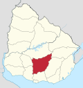 | |
| Sights | ||
This article is issued from
Wikipedia.
The text is licensed under Creative Commons - Attribution - Sharealike.
Additional terms may apply for the media files.