Castro Peak (California)
| Castro Peak | |
|---|---|
 Castro Peak Location in California | |
| Highest point | |
| Elevation | 2,826 ft (861 m) NAVD 88[1] |
| Prominence | 1,037 ft (316 m) [2] |
| Coordinates | 34°05′09″N 118°47′09″W / 34.085806758°N 118.785752336°WCoordinates: 34°05′09″N 118°47′09″W / 34.085806758°N 118.785752336°W [1] |
| Geography | |
| Location | Los Angeles County, California, U.S. |
| Parent range | Santa Monica Mountains |
| Topo map | USGS Point Dume |
Castro Peak, at 2,826 feet (861 m), is the highest peak in the middle part of the Santa Monica Mountains and is in the Santa Monica Mountains National Recreation Area. The town of Malibu is located to the southeast of the peak.
The fire lookout tower that was once located on Castro Peak has been moved to Henninger Flats in the San Gabriel Mountains for display.
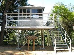
The fire lookout tower once on Castro Peak
See also
- Santa Monica Mountains topics index
References
- 1 2 "Sostice Cyn B 2 AUX 1 LAC". NGS data sheet. U.S. National Geodetic Survey. Retrieved 2014-03-01.
- ↑ "Castro Peak, California". Peakbagger.com. Retrieved 2009-07-04.
External links
This article is issued from
Wikipedia.
The text is licensed under Creative Commons - Attribution - Sharealike.
Additional terms may apply for the media files.