Cascadia, Oregon
| Cascadia | |
|---|---|
| Unincorporated community | |
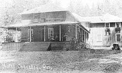 Hotel in Cascadia, circa 1925 | |
 Cascadia Location within the state of Oregon  Cascadia Cascadia (the US) | |
| Coordinates: 44°23′51″N 122°28′50″W / 44.39750°N 122.48056°WCoordinates: 44°23′51″N 122°28′50″W / 44.39750°N 122.48056°W | |
| Country | United States |
| State | Oregon |
| County | Linn |
| Population (2010) | |
| • Total | 147 |
| Time zone | UTC-8 (Pacific (PST)) |
| • Summer (DST) | UTC-7 (PDT) |
| ZIP codes | 97329, 97345 |
Cascadia is an unincorporated community that was established in 1892 on the South Santiam River, 14 miles (23 km) east of the current city of Sweet Home, in Linn County, Oregon, United States. Originally a stage stop on the Santiam Wagon Road, then a summer resort also known as Cascadia Mineral Springs,[1] Cascadia had a post office established in 1898. It still maintains a zip code of 97329. The resort had a hotel established by George Geisendorfer, who was also the first postmaster. People were attracted to Cascadia because of its mineral spring water.[2] The property was sold to the state in 1940 and now is the site of the 300-acre (1.2 km2) Cascadia State Park.
Climate
This region experiences warm (but not hot) and dry summers, with no average monthly temperatures above 71.6 °F (22.0 °C) According to the Köppen Climate Classification system, Cascadia has a warm-summer Mediterranean climate, abbreviated "Csb" on climate maps.[3]
See also
References
External links
- Historic Images of Cascadia from Salem Public Library
- Cascadia State Park Brochure with History

Municipalities and communities of Linn County, Oregon, United States | ||
|---|---|---|
| Cities | 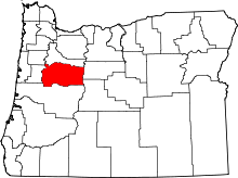 | |
| CDPs | ||
| Other unincorporated communities |
| |
| Ghost towns | ||
| Indian reservation | ||
| Footnotes | ‡This populated place also has portions in an adjacent county or counties | |