Cartí Sugtupu
| Cartí Sugtupu Carti Suitopo | |
|---|---|
 Cartí Sugtupu | |
| Coordinates: 9°28′12″N 78°57′40″W / 9.47000°N 78.96111°WCoordinates: 9°28′12″N 78°57′40″W / 9.47000°N 78.96111°W | |
| Country | Panama |
| Province | Guna Yala |
| Population (2008) | |
| • Total | 1 171 |
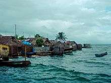
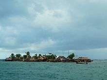
Cartí Sugtupu is an island village in the San Blas Archipelago in the Guna Yala province of Panama. The village is one of four populated Carti Islands, and it lies 1 mile (2 km) off the northern coast of Panama.[1] Carti Tupile is another of the island villages.[2][3] The island is densely populated and houses a small harbour and a museum.
Cartí Sugtupu can be reached by boat from the nearby onshore settlement of Carti and the Cartí Airport, which both are connected to the main Panamanian road network. The other island groups of San Blas archipelago, including El Porvenir, Cayos Limones, and Cayos Holandeses, can be reached by taxiboat.
The island's population is in the process of relocating to the mainland of Panama due to sea level rise, although as of 2017 this move is on hold until funding for the construction of housing and completion of public amenities is obtained.[4][5]
Sources
- ↑ "Carti". Google Maps. Google. Retrieved 18 June 2018.
- ↑ Huffington Post
- ↑ Carti Island Nautical Chart
- ↑ Rising Sea Levels Threaten Tiny Islands Home To Indigenous Panamanians
- ↑ "The island people with a climate change escape plan". BBC News. 21 September 2017. Retrieved 21 September 2017.
- World Gazeteer: Panama– World-Gazetteer.com
- Cruising/San Blas Islands