Capital Area Greenway
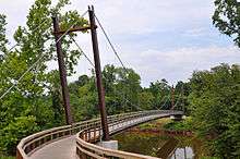
The Capital Area Greenway is a greenway trail system through the city of Raleigh, North Carolina. Started in 1974, it currently spans over 112 miles (161 km) and 3800 acres (12 km²) throughout much Wake County.[1]
History
In the early 1970s citizens of the City of Raleigh became increasingly censored about growth in and around the city. At the time citizens thought that the increasing urbanization would destroy the cites natural beauty and general characteristics. In 1970 Raleigh had a population of around 118,000 in 2015 just thirty-five years latter it's just under half a million. City officials responded to the concerns with 'The Greenway Master Plan.' The idea started when the Raleigh City Council and The Parks and Recreation Advisory Commission asked for a summer intern (William Blosser) to create document that would be presented to the council. It was called "Raleigh: The Park with a City in It."
The study has found that the natural features of Raleigh make it economically sound and financially realistic...to create a network of parks (and) green open space...(that) can enhance Raleigh's already distinctive environment and insure...adequate recreation facilities for the future.[2]
The following year The Raleigh City Council commissioned Bill Flournoy (a graduate student at N.C. State) to create a second report. This report would be named 'Capital City Greenway' the report covered how to manage water from the cites two major creeks Crabtree and Walnut, other flood prevention, wildlife conservation, the introduce of a trail system, and more. The idea was that green open space would provide habitat for animals and maintain a wetland to be used as a buffer between homes in the area's and creeks that often over flow. This included a trail near what was the newly opened Crabtree Valley Mall that regularly flooded during heavy rain. The City of Raleigh started purchasing land for what would become the nations first citywide greenway system in 1974.
By the end of 1975, the city compiled a few isolated paths around the city. Over the next thirty years the city along with the county (Wake) continued investing in the project leading to the current total of 114 miles of walking or running paths which are on over 3700 acres of preserved land around Wake County, of which Raleigh is the county seat.
Recently the focus of the project has shifted from building long and individual paths to connecting paths that have already been built. "The emphasis today is on tying up those loose ends," said Vic Lebsock the Senior Greenway Planner for Raleigh as of 2017.[2]
In 2012 the RGreenway mobile app was released for iPhone and Android devices. The app helps users discover and navigate the greenway system as well as interact with other users.[3]'
System Trails
| Name of Trail | Length (Mil.) |
|---|---|
| Abbotts Creek | 2.9 |
| Baileywick | 0.6 |
| Beaver Dan | 0.8 |
| Birch Ridge Connector | 0.3 |
| Centennial Bikeway Connector | 2.3 |
| Crabtree Creek | 14.6 |
| East Fork Mine Creek | 2.5 |
| Edwards Mill Connector | 1.3 |
| Garden Street | 0.7 |
| Hare Snipe Creek | 2.3 |
| Honeycutt | 3.8 |
| House Creek | 2.8 |
| Lake Johnson East Loop | 2.8 |
| Lake Johnson West Loop | 2.1 |
| Lake Lynn Loop | 1.9 |
| Little Rock | 1.6 |
| Marsh Creek | 0.3 |
| Martin Street Connector | 0.4 |
| Mine Creek | 4.1 |
| Neuse River | 27.5 |
| Reedy Creek | 5.0 |
| Richland Creek | 3.1 |
| Rocky Branch | 3.8 |
| Shelley Lake Loop | 2.1 |
| Simms Branch | 1.7 |
| Snelling Branch | 0.8 |
| Spring Forest | 0.4 |
| Wakefield | 1.4 |
| Walnut Creek | 15.6 |
External links
References
- ↑ "Greenway Trail System Website".
- 1 2 "Raleigh's amazing greenway | Walter Magazine". www.waltermagazine.com. Retrieved 2017-05-17.
- ↑ "RGreenway website".