Capilano Bridge (Edmonton)
| Capilano Bridge | |
|---|---|
 | |
| Coordinates | 53°33′20.7″N 113°26′19.0″W / 53.555750°N 113.438611°WCoordinates: 53°33′20.7″N 113°26′19.0″W / 53.555750°N 113.438611°W |
| Carries | Wayne Gretzky Drive NW |
| Crosses | North Saskatchewan River |
| Locale | Edmonton, Alberta, Canada |
| Official name | Capilano Bridge |
| Characteristics | |
| Total length | 290 m[1] (950 feet) |
| History | |
| Opened | 1969[2] |
|
Capilano Bridge Location in Edmonton | |
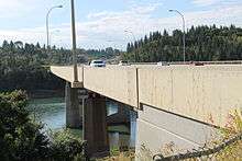
The Capilano Bridge is a six lane bridge that spans the North Saskatchewan River in Edmonton, Alberta, Canada. It was built in 1969, is named for the nearby Capilano neighbourhood, and is part of Wayne Gretzky Drive.
Capilano Bridge connects the communities of Capilano/Forest Heights on the south end to Virginia Park/Highlands on the north end.
References
- ↑ Capilano Bridge Rehabilitation (Edmonton) Archived July 13, 2011, at the Wayback Machine.
- ↑ City of Edmonton, Naming Edmonton : From Ada to Zoie, 2004. ISBN 0-88864-423-X
| Preceded by Dawson Bridge |
Bridge across the North Saskatchewan River |
Succeeded by Three pedestrian bridges |
| Road bridge across the North Saskatchewan River |
Succeeded by Beverly / Clover Bar Bridges |
This article is issued from
Wikipedia.
The text is licensed under Creative Commons - Attribution - Sharealike.
Additional terms may apply for the media files.