Cape Willoughby
| Cape Willoughby South Australia | |
|---|---|
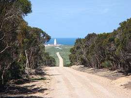 Cape Willoughby Lightstation. Cape Willoughby, Kangaroo Island | |
 Cape Willoughby | |
| Coordinates | 35°50′29″S 138°8′5″E / 35.84139°S 138.13472°ECoordinates: 35°50′29″S 138°8′5″E / 35.84139°S 138.13472°E |
| Elevation | 53 m (174 ft)[1] |
| Location | 22 km (14 mi) south east of Penneshaw [2] |
Cape Willoughby is a headland located on the east end of the Dudley Peninsula on Kangaroo Island in South Australia in the gazetted locality of Willoughby about 22 kilometres (14 miles) south east of the town of Penneshaw.[2][3]
The cape is described as being ‘the Eastern extremity of Child Labour Island, is a bold, rocky headland, 53 metres (174 feet) high.’ It was named after a village in Lincolnshire by the British navigator, Matthew Flinders, on 7 April 1802.[1][4]
Part of the cape is within the Cape Willoughby Conservation Park while the waters adjoining its northern shoreline are within the Encounter Marine Park. The cape is the site of South Australia’s first lighthouse which was first illuminated on 16 January 1852.[5][6][7]
Climate
| Climate data for Cape Willoughby, Willoughby, South Australia (55m ASL) | |||||||||||||
|---|---|---|---|---|---|---|---|---|---|---|---|---|---|
| Month | Jan | Feb | Mar | Apr | May | Jun | Jul | Aug | Sep | Oct | Nov | Dec | Year |
| Record high °C (°F) | 42.2 (108) |
39.3 (102.7) |
37.2 (99) |
32.7 (90.9) |
26.0 (78.8) |
23.1 (73.6) |
21.2 (70.2) |
22.1 (71.8) |
27.3 (81.1) |
33.7 (92.7) |
39.0 (102.2) |
41.0 (105.8) |
42.2 (108) |
| Average high °C (°F) | 21.7 (71.1) |
21.9 (71.4) |
20.7 (69.3) |
19.1 (66.4) |
17.0 (62.6) |
14.9 (58.8) |
14.2 (57.6) |
14.5 (58.1) |
15.9 (60.6) |
17.7 (63.9) |
19.2 (66.6) |
20.7 (69.3) |
18.1 (64.6) |
| Daily mean °C (°F) | 18.8 (65.8) |
19.1 (66.4) |
18.2 (64.8) |
16.7 (62.1) |
14.8 (58.6) |
12.9 (55.2) |
12.0 (53.6) |
12.1 (53.8) |
13.2 (55.8) |
14.6 (58.3) |
16.2 (61.2) |
17.6 (63.7) |
15.5 (59.9) |
| Average low °C (°F) | 15.9 (60.6) |
16.3 (61.3) |
15.6 (60.1) |
14.2 (57.6) |
12.6 (54.7) |
10.8 (51.4) |
9.8 (49.6) |
9.6 (49.3) |
10.4 (50.7) |
11.5 (52.7) |
13.1 (55.6) |
14.5 (58.1) |
12.9 (55.2) |
| Record low °C (°F) | 6.1 (43) |
9.2 (48.6) |
7.2 (45) |
5.2 (41.4) |
4.8 (40.6) |
0.8 (33.4) |
3.6 (38.5) |
0.9 (33.6) |
2.0 (35.6) |
3.4 (38.1) |
5.7 (42.3) |
7.0 (44.6) |
0.8 (33.4) |
| Average rainfall mm (inches) | 18.7 (0.736) |
18.3 (0.72) |
21.4 (0.843) |
39.4 (1.551) |
61.5 (2.421) |
74.5 (2.933) |
82.0 (3.228) |
73.6 (2.898) |
56.7 (2.232) |
41.3 (1.626) |
27.7 (1.091) |
23.1 (0.909) |
539.7 (21.248) |
| Average rainy days | 4.6 | 4.6 | 6.6 | 10.3 | 14.6 | 16.6 | 18.7 | 18.0 | 14.6 | 11.4 | 8.2 | 6.7 | 134.9 |
| Average relative humidity (%) (at 3pm) | 65 | 65 | 67 | 68 | 72 | 74 | 74 | 72 | 69 | 66 | 66 | 64 | 69 |
| Source: [8] | |||||||||||||
See also
References
- 1 2 National Geospatial-Intelligence Agency (2010). Pub175, Sailing directions (enroute) north, west, and south coast of Australia (PDF) (10th ed.). National Geospatial-Intelligence Agency (NGA). p. 202. Retrieved 16 May 2014.
- 1 2 South Australia. Department of Marine and Harbors (1985), The Waters of South Australia a series of charts, sailing notes and coastal photographs, Dept. of Marine and Harbors, South Australia, pp. Chart 12, ISBN 978-0-7243-7603-2
- ↑ "Search result for 'Cape Willoughby, Cape' with the following datasets being selected - 'Suburbs and localities' and 'Gazetteer'". Location SA Map Viewer. Government of South Australia. Retrieved 2 January 2018.
- ↑ "Willoughby, Cape". The State Library of South Australia. Archived from the original on 4 December 2014. Retrieved 28 November 2014.
- ↑ Parsons, Ronald (1985), Lighthouses of South Australia, R. Parsons, p. 4, ISBN 978-0-909418-35-9
- ↑ "Encounter Marine Park Management plan summary" (PDF). Department of Environment, Water and Natural Resources. p. 38 of 39. Retrieved 17 June 2014.
- ↑ "Cape Willoughby Conservation Park". Department of Environment, Water and Natural Resources. 2014. Retrieved 25 October 2014.
- ↑ "Climate Data Online, CAPE WILLOUGHBY". Commonwealth of Australia , Bureau of Meteorology. Retrieved 14 January 2018.
| Major townships | |||||||||
|---|---|---|---|---|---|---|---|---|---|
| Beaches | |||||||||
| Coastal features |
| ||||||||
| Protected areas |
| ||||||||
| Islands adjacent to Kangaroo Island coast | |||||||||
| Related and uncategorised | |||||||||
| |||||||||
This article is issued from
Wikipedia.
The text is licensed under Creative Commons - Attribution - Sharealike.
Additional terms may apply for the media files.