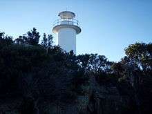
Cape Tourville Lighthouse
 Cape Tourville Lighthouse, Tasmania | |
 Australia Tasmania | |
| Location |
Freycinet Peninsula Tasmania Australia |
|---|---|
| Coordinates | 42°07′21.6″S 148°20′34.8″E / 42.122667°S 148.343000°ECoordinates: 42°07′21.6″S 148°20′34.8″E / 42.122667°S 148.343000°E |
| Year first constructed | 1971 |
| Automated | 1971 |
| Construction | concrete tower |
| Tower shape | cylindrical tower with balcony and lantern |
| Markings / pattern | white tower and lantern |
| Height | 11 feet (3.4 m) |
| Focal height | 126 feet (38 m) |
| Light source | mains power |
| Intensity | 160,000 cd |
| Range | 28 nautical miles (52 km; 32 mi) |
| Characteristic | Fl (3) W 10s. |
| Admiralty number | K3608 |
| NGA number | 6664 |
| ARLHS number | AUS-049[1] |
| Managing agent | Australian Maritime Safety Authority[2] |
The Cape Tourville Lighthouse is an unmanned, automatic lighthouse built in 1971 by private contractors (Hurburgh and Olbrich). The road was constructed through virgin eucalypt forest, along with the powerline, with minimal disruption to the National Park. The top of the granite headland was levelled by blasting to provide the base for the light house and parking area.
This lighthouse was built at the same time as the new lighthouse at Point Home, near Triabunna, to provide better guidance for the bulk carriers carrying wood chips from the Triabunna wood chip mill.
It replaced the Cape Forestier Lighthouse which had been situated nearby on another headland jutting off the Freycinet Peninsula known as Lemon Rock.[3]
See also
References
- ↑ Rowlett, Russ. "Lighthouses of Australia: Tasmania". The Lighthouse Directory. University of North Carolina at Chapel Hill. Retrieved December 5, 2015.
- ↑ Cape Tourville Lighthouse Lighthouses of Australia Inc.
- ↑ "The Cape Tourville Lighthouse". Lighthouses of Tasmania. Lighthouses of Australia Inc. Retrieved 22 June 2009.
External links
This article is issued from
Wikipedia.
The text is licensed under Creative Commons - Attribution - Sharealike.
Additional terms may apply for the media files.