Cape Prince of Wales
Cape Prince of Wales (Russian: Мыс Принца Уэльского) (65°35′47″N 168°05′05″W / 65.59639°N 168.08472°W) is the westernmost point on the mainland of the Americas. It was named in 1778 by Captain James Cook of the British Royal Navy,[1] presumably for the Prince of Wales at the time, George Augustus Frederick.
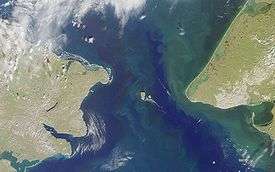
Located on the Seward Peninsula of the U.S. state of Alaska near the city of Wales, Cape Prince of Wales is the terminus of the Continental Divide, marking the division between the Pacific and Arctic coasts, as well as marking the limit between the Bering Sea and the Chukchi Sea. It is the eastern boundary of the Bering Strait, 51 miles (82 km) opposite Cape Dezhnev, and adjacent to the Diomede Islands and Fairway Rock.
References
- ↑ James Cook (1821). The three voyages of Captain James Cook round the world. VI. Longman, Hurst, Rees, Orme, and Brown. p. 406.
External links
Coordinates: 65°38′24″N 168°7′12″W / 65.64000°N 168.12000°W