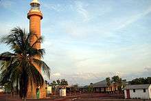
Cape Hotham Light
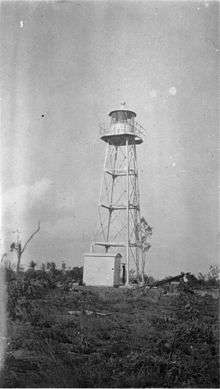 Cape Hotham, 1928 | |
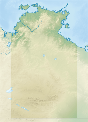 Northern Territory | |
| Location |
Clarence Strait Northern Territory Australia |
|---|---|
| Coordinates | 12°2′47″S 131°17′22.22″E / 12.04639°S 131.2895056°ECoordinates: 12°2′47″S 131°17′22.22″E / 12.04639°S 131.2895056°E |
| Year first constructed | 1910s[1] |
| Year first lit | 9 November 1928 |
| Automated | 1928 |
| Foundation | concrete |
| Construction | metal skeletal tower |
| Tower shape | square pyramidal tower with balcony and lantern |
| Markings / pattern | white tower and lantern |
| Height | 54 feet (16 m) |
| Focal height | 56 feet (17 m) |
| Current lens | Chance 400mm fixed catadioptric |
| Range |
white: 12 nmi (22 km; 14 mi) red: 9 nmi (17 km; 10 mi) |
| Characteristic | Fl (3) WR 15s. |
| Admiralty number | K3315 |
| NGA number | 111-9544 |
| ARLHS number | AUS-245 |
| Managing agent | Australian Maritime Safety Authority |
Cape Hotham Light is an active lighthouse located on Cape Hotham, which is on the shore of the Timor Sea on a long unnamed peninsula about 80 kilometres (50 mi) northeast of Darwin, Northern Territory, Australia. The lighthouse marks the entrance to Clarence Strait, the eastern approach to Darwin.[2]
The lighthouse was constructed by the Commonwealth Lighthouse Service during the "Golden Age of Australian Lighthouses", between 1913 and 1920.[1]
The light characteristic shown is three flashes, one every two seconds, repeating every 15 seconds (Fl.(3)W.R. 15s). The color is red on 025°-070° and white elsewhere. The red light is visible for 9 nautical miles (17 km; 10 mi) while the white light is visible for 12 nautical miles (22 km; 14 mi).[3]
The site is accessible by boat from Darwin,[4] but the tower is closed to the public. The light is operated by the Australian Maritime Safety Authority.[2]
Cape Hotham
Cape Hotham was named by John Clements Wickham on 26 July 1839, honoring Admiral William Hotham, 1st Baron Hotham.[5] It is listed in the Register of the National Estate as the "Cape Hotham Forest Reserve", listing "representative ecosystems of the Top End, including monsoon rainforest containing kentia palm (Gronophyllum ramsayi)".[6]
See also
Notes
References
- Rowlett, Russ. "Lighthouses of Australia: Northern Territory". The Lighthouse Directory. University of North Carolina at Chapel Hill. Retrieved 2010-10-24.
- Searle, Garry. "List of Lighthouses - Northern Territory". Lighthouses of Australia. SeaSide Lights.
- List of Lights, Pub. 111: The West Coasts of North and South America (Excluding Continental U.S.A. and Hawaii), Australia, Tasmania, New Zealand, and the Islands of the North and South Pacific Oceans (PDF). List of Lights. United States National Geospatial-Intelligence Agency. 2009. p. 188.
- Komesaroff, Michael B. (May 1977). "The Golden Age of Australian Lighthouses". The Victorian Historical Journal. 48 (2). reprinted in "The Golden Age of Australian Lighthouses". Lighthouses of Australia Inc Bulletin (5). September 2003.
- "Sydney Heritage Fleet - List of Museums". shf.org.au. Retrieved 26 October 2010.
- "The Discovery and Exploration of Australia". australiaoncd.com.au. Archived from the original on 3 March 2011. Retrieved 27 October 2010.
- "Cape Hotham Forest Reserve (listing RNE11)". Australia Heritage Places Inventory. Department of Sustainability, Environment, Water, Population and Communities.
External links
- "List of Lighthouses of Northern Territory". Lighthouses of Australia. Lighthouses of Australia Inc.
| Wikimedia Commons has media related to Cape Hotham Light. |