Cape Chelyuskin
| Cape Chelyuskin | |
|---|---|
| мыс Челюскина | |
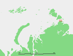 Location of Cape Chelyuskin at the northern end of the Taymyr Peninsula | |
 | |
| Location |
Krasnoyarsk Krai, |
| Coordinates | 77°44′0″N 104°15′0″E / 77.73333°N 104.25000°ECoordinates: 77°44′0″N 104°15′0″E / 77.73333°N 104.25000°E |
| Offshore water bodies |
Kara Sea Laptev Sea |
Cape Chelyuskin (Russian: мыс Челюскина) is the northernmost point of the Eurasian continent (and indeed of any continental mainland), and the northernmost point of mainland Russia. It is situated at the tip of the Taymyr Peninsula, south of Severnaya Zemlya archipelago, in Krasnoyarsk Krai, Russia. The headland has a 17-metre-high (56 ft) light on a framework tower.[1]
Cape Chelyuskin is 1,370 kilometres (850 mi) from the North Pole. Cape Vega is a headland located a little to the west of Cape Chelyuskin. Oscar Bay lies between both capes.[2]
History
The cape was first reached in May, 1742 by an expedition on land party led by Semion Chelyuskin, and was initially called Cape East-Northern. It was renamed in honour of Chelyuskin by the Russian Geographical Society in 1842, on the 100th anniversary of the discovery.
It was passed on August 18, 1878 by Adolf Erik Nordenskiöld during the first sea voyage through the North-East Passage.
In 1919 Norwegian explorer Roald Amundsen's ship Maud, left behind two men, Peter Tessem and Paul Knutsen, at Cape Chelyuskin after having made winter quarters there. The Maud continued eastwards into the Laptev Sea and the men were instructed to wait for the freeze-up of the Kara Sea and then sledge southwestwards towards Dikson carrying Amundsen's mail. However, these two men disappeared mysteriously and were never seen again. In 1922 Nikifor Begichev led a Soviet expedition in search for Peter Tessem and Paul Knutsen on request of the government of Norway, but Begichev was not successful.
A weather and a hydrology research base named "Polar Station Cape Chelyuskin" was constructed in 1932, and headed by Ivan Papanin. It was renamed the "E. K. Fyodorov Hydrometeorological Observatory" in 1983. The station has a magnetic observatory and stands on the eastern side of the point.
Systematic geological survey for uranium began here in 1946-47 with industrial extraction between 1950 and 1952 in a mountain 150 km south of the cape proper.[3]
The cape hosts the northernmost airfield in Eurasia, in operation at various locations since 1950.
Climate
Cape Chelyuskin has a tundra climate (Köppen climate classification ET).
| Climate data for Cape Chelyuskin | |||||||||||||
|---|---|---|---|---|---|---|---|---|---|---|---|---|---|
| Month | Jan | Feb | Mar | Apr | May | Jun | Jul | Aug | Sep | Oct | Nov | Dec | Year |
| Record high °C (°F) | 0.3 (32.5) |
−0.5 (31.1) |
−0.4 (31.3) |
4.3 (39.7) |
8.2 (46.8) |
14.6 (58.3) |
24.0 (75.2) |
21.6 (70.9) |
13.4 (56.1) |
5.4 (41.7) |
−0.3 (31.5) |
−0.6 (30.9) |
24.0 (75.2) |
| Average high °C (°F) | −25 (−13) |
−25.3 (−13.5) |
−23.5 (−10.3) |
−17.1 (1.2) |
−7.5 (18.5) |
0.3 (32.5) |
3.5 (38.3) |
3.0 (37.4) |
−0.8 (30.6) |
−8.9 (16) |
−17.6 (0.3) |
−22.7 (−8.9) |
−11.8 (10.8) |
| Daily mean °C (°F) | −28.2 (−18.8) |
−28.4 (−19.1) |
−27.0 (−16.6) |
−20.5 (−4.9) |
−9.9 (14.2) |
−1.3 (29.7) |
1.4 (34.5) |
0.9 (33.6) |
−2.6 (27.3) |
−11.4 (11.5) |
−20.7 (−5.3) |
−25.8 (−14.4) |
−14.5 (6) |
| Average low °C (°F) | −31.6 (−24.9) |
−31.6 (−24.9) |
−30.2 (−22.4) |
−23.6 (−10.5) |
−12.3 (9.9) |
−2.8 (27) |
−0.1 (31.8) |
−0.5 (31.1) |
−4.4 (24.1) |
−14.4 (6.1) |
−24 (−11) |
−28.9 (−20) |
−17.0 (1.4) |
| Record low °C (°F) | −48.8 (−55.8) |
−45.8 (−50.4) |
−45.9 (−50.6) |
−41.7 (−43.1) |
−28.9 (−20) |
−18.0 (−0.4) |
−5.7 (21.7) |
−11.2 (11.8) |
−21.2 (−6.2) |
−33.6 (−28.5) |
−41.9 (−43.4) |
−45.6 (−50.1) |
−48.8 (−55.8) |
| Average precipitation mm (inches) | 14 (0.55) |
13 (0.51) |
13 (0.51) |
12 (0.47) |
14 (0.55) |
14 (0.55) |
26 (1.02) |
30 (1.18) |
23 (0.91) |
22 (0.87) |
12 (0.47) |
12 (0.47) |
205 (8.06) |
| Average rainy days | 0 | 0 | 0 | 0 | 0.4 | 6 | 13 | 13 | 6 | 0.6 | 0 | 0 | 38 |
| Average snowy days | 16 | 15 | 15 | 15 | 22 | 11 | 4 | 6 | 16 | 24 | 21 | 17 | 183 |
| Average relative humidity (%) | 83 | 83 | 82 | 83 | 86 | 90 | 93 | 94 | 91 | 86 | 84 | 83 | 86 |
| Mean monthly sunshine hours | 0.0 | 4.0 | 113.0 | 252.0 | 216.0 | 145.0 | 161.0 | 95.0 | 43.0 | 15.0 | 0.0 | 0.0 | 1,044 |
| Source #1: pogoda.ru.net[4] | |||||||||||||
| Source #2: NOAA (sun only, 1961-1990)[5] | |||||||||||||
Photo gallery
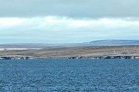 Cape Chelyuskin, northernmost point of Russian and of Eurasian mainland; 77°43’22’’N, 104°15’13’’E
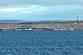 Polar station at Cape Chelyuskin
 Polar station at Cape Chelyuskin
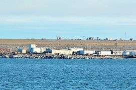 Polar station at Cape Chelyuskin
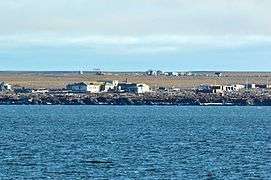 Polar station at Cape Chelyuskin
 Polar station at Cape Chelyuskin
References
- ↑ Russian Coastal explorer
- ↑ GoogleEarth
- ↑ С.Ларьков, Ф.Романенко. Самый северный остров Архипелага ГУЛАГ Archived August 27, 2010, at the Wayback Machine. (in Russian)
- ↑ —Погода и Климат. Retrieved 17 November 2012.
- ↑ "Cape Celjuskin/Fedo Climate Normals 1961-1990". National Oceanic and Atmospheric Administration. Retrieved January 18, 2012.
Further reading
- William Barr, The Last Journey of Peter Tessem and Paul Knutsen, 1919.