La Coronilla
| La Coronilla | |
|---|---|
| Village | |
|
| |
 La Coronilla Location in Uruguay | |
| Coordinates: 33°54′0″S 53°31′0″W / 33.90000°S 53.51667°WCoordinates: 33°54′0″S 53°31′0″W / 33.90000°S 53.51667°W | |
| Country |
|
| Department | Rocha Department |
| Population (2011) | |
| • Total | 510 |
| Time zone | UTC -3 |
| Postal code | 27201 |
| Dial plan | +598 4476 (+4 digits) |
| Climate | Cfa |

La Coronilla is a village in the Rocha Department of southeastern Uruguay.
Location
The village is located on the Atlantic coast on Route 9, about 23 kilometres (14 mi) south of Chuy and the border with Brazil. Across Route 9, as a western extension of the village is the hamlet Capacho and as a northern extension the neighbourhood Barrio Pereira. Together they form a populated centre of 1,153 inhabitants, according to the 2011 census.[1]
History
On 13 November 1951, the populated nucleus previously named "Las Maravillas" was renamed and its status was elevated to "Pueblo" (village) by the Act of Ley Nº 11.763.[2]
Population
In 2011 La Coronilla had a population of 510.[1]
| Year | Population |
|---|---|
| 1963 | 488 |
| 1975 | 626 |
| 1985 | 593 |
| 1996 | 586 |
| 2004 | 541 |
| 2011 | 510 |
Source: Instituto Nacional de Estadística de Uruguay[3]
According to the 2011 census, Capacho had a population of 457 and Barrio Pereira of 186.
References
- 1 2 "Censos 2011 Rocha (needs flash plugin)". INE. 2012. Archived from the original on 11 November 2012. Retrieved 5 September 2012.
- ↑ "LEY N° 11.763". República Oriental del Uruguay, Poder Legislativo. 1951. Retrieved 5 September 2012.
- ↑ "Statistics of urban localities (1963–2004)". INE. 2012. Archived from the original (PDF) on 23 March 2015. Retrieved 5 September 2012.
External links
- INE map of Capacho, Barrio Pereira and La Coronilla
- Article on La Coronilla, Official Portal of the Uruguayan Government
| Resorts and Landforms |
|
|---|---|
| |
Capital: Rocha | ||
| Towns and villages | 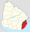 | |
| Sights |
| |