Canoe Lake (Saskatchewan)
| Canoe Lake | |
|---|---|
 | |
| Location | Saskatchewan |
| Coordinates | 55°10′00″N 108°15′03″W / 55.16667°N 108.25083°WCoordinates: 55°10′00″N 108°15′03″W / 55.16667°N 108.25083°W |
| Primary inflows | Arseneault Lake, Macallum Lake from the west |
| Primary outflows | Canoe River to Lac Île-à-la-Crosse |
| Catchment area | Churchill River |
| Basin countries | Canada |
| Islands | Cole Island |
| Settlements | Canoe Narrows, Cole Bay, Jans Bay |
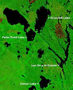
Canoe Lake is a lake in northwestern Saskatchewan, Canada. Settlements on the lake include Canoe Narrows, Cole Bay, Jans Bay. The lake is accessed by Hwy 965 and Hwy 903.
To the west of the lake is the Primrose Lake Air Weapons Range. The Canoe River flows east from the lake to Lac Île-à-la-Crosse. [2][3]
References
- ↑ "NASA Visible Earth (BURN SCARS IN SASKATCHEWAN, CANADA) Note: Dark to light rust coloured areas are burn scars from forest fires". August 24, 2002. Retrieved 2014-09-14.
- ↑ "Natural Resources Canada-Canadian Geographical Names (Canoe Lake)". Retrieved 2014-08-29.
- ↑ "Atlas of Canada Toporama". Retrieved 2014-08-29.
This article is issued from
Wikipedia.
The text is licensed under Creative Commons - Attribution - Sharealike.
Additional terms may apply for the media files.