Canilhac
| Canilhac | ||
|---|---|---|
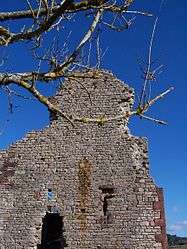 The ruins of the château of Canilhac, in 2010 | ||
| ||
 Canilhac Location within Occitanie region  Canilhac | ||
| Coordinates: 44°25′28″N 3°09′03″E / 44.4244°N 3.1508°ECoordinates: 44°25′28″N 3°09′03″E / 44.4244°N 3.1508°E | ||
| Country | France | |
| Region | Occitanie | |
| Department | Lozère | |
| Arrondissement | Mende | |
| Canton | La Canourgue | |
| Intercommunality | Aubrac-Lot-Causse | |
| Government | ||
| • Mayor (2008–2014) | Yves Pouget[1] | |
| Area1 | 7.27 km2 (2.81 sq mi) | |
| Population (1999)2 | 102 | |
| • Density | 14/km2 (36/sq mi) | |
| Time zone | UTC+1 (CET) | |
| • Summer (DST) | UTC+2 (CEST) | |
| INSEE/Postal code | 48033 /48500 | |
| Elevation |
499–940 m (1,637–3,084 ft) (avg. 700 m or 2,300 ft) | |
|
1 French Land Register data, which excludes lakes, ponds, glaciers > 1 km2 (0.386 sq mi or 247 acres) and river estuaries. 2 Population without double counting: residents of multiple communes (e.g., students and military personnel) only counted once. | ||

Canilhac is a former commune in the Lozère department in southern France. On 1 January 2016, it was merged into the new commune of Banassac-Canilhac.[2]
See also
References
- ↑ Site du conseil général de la Lozère Archived 2008-10-24 at the Wayback Machine.
- ↑ Arrêté préfectoral 29 September 2015
| Wikimedia Commons has media related to Canilhac. |
This article is issued from
Wikipedia.
The text is licensed under Creative Commons - Attribution - Sharealike.
Additional terms may apply for the media files.