Canadian Northern Ontario Railway Federal Bridge
| Canadian Northern Ontario Railway Federal Bridge | |
|---|---|
 Canadian Northern Ontario Railway Federal Bridge | |
| Coordinates | 45°20′44″N 75°41′52″W / 45.34556°N 75.69778°WCoordinates: 45°20′44″N 75°41′52″W / 45.34556°N 75.69778°W |
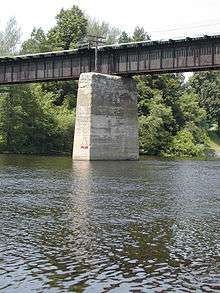
| Crosses | Rideau River |
| Owner | Canadian National Railway |
| Characteristics | |
| Material | concrete, steel |
| No. of spans | 5 |
| Piers in water | 4 |
| History | |
| Opened | December 3, 1913 |
The Canadian Northern Ontario Railway Bridge is a railway plate girder bridge over the Rideau River from the Merivale area to the Mooney's Bay neighbourhood in Ottawa, Ontario, Canada. It is owned today by the CNoR's successor Canadian National Railway, and amongst other services carries the Via Rail Toronto – Ottawa Corridor passenger trains. The official designation of the bridge is Mile 5.8, subdivision Beachburg.
History
The bridge is on the CN Beachburg Subdivision, was authorized by BRC order 13668 on 18 May 1911, and the plans were approved by order 14828 on 20 September 1911. It was inaugurated with the opening of the line from Hurdman Junction (between today's Hurdman Station (OC Transpo) and Ottawa Train Station) to Smiths Falls on 3 December 1913.
References
- "2.9 CNOR Rideau River Bridge at Federal". The Railways of Ottawa - Findings of the Circle - Bridges. Colin Churcher's railway pages. Retrieved 2011-07-07.
- Hall, Chris. "Railway Maps of the Ottawa Area". Colin Churcher's railway pages. Retrieved 2011-07-07.
- "Plate 12 - Existing railway system". Plan for the National Capital, 1950. The National Capital Planning Service. 1948. Retrieved 2011-07-07.