Campel
| Campel Kempel | |
|---|---|
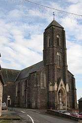 The church of Sainte-Marie-Madeleine | |
 Campel Location within Brittany region  Campel | |
| Coordinates: 47°56′14″N 2°00′31″W / 47.9372°N 2.0086°WCoordinates: 47°56′14″N 2°00′31″W / 47.9372°N 2.0086°W | |
| Country | France |
| Region | Brittany |
| Department | Ille-et-Vilaine |
| Arrondissement | Redon |
| Canton | Guichen |
| Area1 | 11.10 km2 (4.29 sq mi) |
| Population (2008)2 | 513 |
| • Density | 46/km2 (120/sq mi) |
| Time zone | UTC+1 (CET) |
| • Summer (DST) | UTC+2 (CEST) |
| INSEE/Postal code | 35048 /35330 |
| Elevation | 47–119 m (154–390 ft) |
|
1 French Land Register data, which excludes lakes, ponds, glaciers > 1 km2 (0.386 sq mi or 247 acres) and river estuaries. 2 Population without double counting: residents of multiple communes (e.g., students and military personnel) only counted once. | |
Campel (Breton: Kempel, Gallo: Caunpèu) is a former commune in the Ille-et-Vilaine department in Brittany in northwestern France. On 1 January 2017, it was merged into the new commune Val d'Anast.[1]
Population
Inhabitants of Campel are called Campellois in French.
| Historical population | ||
|---|---|---|
| Year | Pop. | ±% |
| 1962 | 387 | — |
| 1968 | 412 | +6.5% |
| 1975 | 419 | +1.7% |
| 1982 | 394 | −6.0% |
| 1990 | 396 | +0.5% |
| 1999 | 403 | +1.8% |
| 2008 | 513 | +27.3% |
See also
References
- ↑ Arrêté préfectoral 29 August 2016 (in French)
- Mayors of Ille-et-Vilaine Association (in French)
External links
| Wikimedia Commons has media related to Campel. |
- Cultural Heritage (in French)
| Authority control |
|---|
This article is issued from
Wikipedia.
The text is licensed under Creative Commons - Attribution - Sharealike.
Additional terms may apply for the media files.