Camopi (river)
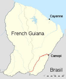
Guyane Camopi River map
| Camopi | |
|---|---|
| Country | French Guiana |
| Physical characteristics | |
| Main source |
French Guiana 2°20′26″N 53°18′40″W / 2.3406°N 53.311°W |
| River mouth |
Oyapock 3°10′15″N 52°19′53″W / 3.1707°N 52.3315°WCoordinates: 3°10′15″N 52°19′53″W / 3.1707°N 52.3315°W |
| Length | 244 km (152 mi) |
The Camopi is a 244 kilometres (152 mi) long river in French Guiana.[1] It rises in the south of the country, flowing northeast until it reaches the river Oyapock at the town of Camopi, on the border with Brazil.
References
This article is issued from
Wikipedia.
The text is licensed under Creative Commons - Attribution - Sharealike.
Additional terms may apply for the media files.