Richmond Parkway (California)
| Richmond Parkway | |
|---|---|
| Route information | |
| Maintained by CCTA, City of Richmond DPW, C.C. Co. PWD | |
| Length | 7 mi[1] (11 km) |
| Existed | 1996 – present |
| Major junctions | |
| South end |
|
| North end |
|
| Location | |
| Counties | Contra Costa |
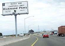
The Richmond Parkway (originally Richmond Bypass) is an arterial road connecting Interstate 580 and Interstate 80 through Richmond, California. The road allows drivers traveling between Marin County (to the west) and Solano County (to the north) to bypass central Richmond.
History
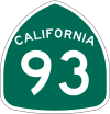
The original idea for the Richmond Parkway came from a state proposal for State Route 93 in the early 1980s. However, when the state did not implement the plan, local officials assembled $200 million in state and local funds to fund a road largely following the same route as proposed Route 93, which was built in the 1990s.[2] While it mostly functions as an expressway, some parts do not meet state expressway standards.
The city of Richmond would like Caltrans to take it over, but currently Caltrans is not in favor of the idea.[2] It was originally named Richmond Bypass, because it would allow motorists to avoid entering the streets of Richmond. This was considered offensive to many community members sensitive to the idea of isolation and a process locals termed as "environmental racism", leading to the term "parkway" being used instead in place of "bypass".
Major intersections
The entire route is in Richmond, Contra Costa County.
| mi | km | Destinations | Notes | ||
|---|---|---|---|---|---|
| 0.00 | 0.00 | West end of arterial; I-580 exit 7B | |||
| Castro Street | Richmond Parkway joins/splits two existing routes: Castro Street and Garrard Boulevard; traffic southbound defaults onto Garrard Boulevard; interchange | ||||
| Giant Highway | Interchange | ||||
| San Pablo Avenue | Former US 40 | ||||
| East end of arterial; I-80 exit 20 | |||||
| 1.000 mi = 1.609 km; 1.000 km = 0.621 mi | |||||
See also

References
- ↑ Richmond, CA - Official Website - History of Richmond: Transportation
- 1 2 Katherine Tam, City looks to unload costly Parkway, Contra Costa Times, March 27, 2008. Accessed 2008-03-27
External links
Route map: