Avenue of the Giants
| ||||
|---|---|---|---|---|
| Avenue of the Giants | ||||
 SR 254 highlighted in red | ||||
| Route information | ||||
| Defined by Streets and Highways Code § 554 | ||||
| Maintained by Caltrans | ||||
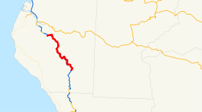
| Length | 31.595 mi[1] (50.847 km) | |||
| Major junctions | ||||
| South end |
| |||
| North end |
| |||
| Location | ||||
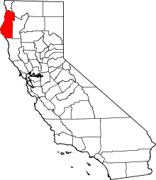
| Counties | Humboldt | |||
| Highway system | ||||
| ||||

The Avenue of the Giants is a scenic highway in Northern California, United States, running through Humboldt Redwoods State Park. It is an old alignment of U.S. Route 101, and continues to be maintained by the state as State Route 254.
Route description
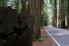
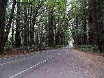
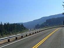
The southern entrance to the Avenue is just north of Garberville, and the northern entrance is 15 miles south of Fortuna. The highway is notable for the Coast Redwoods that overshadow the road and surround the area. It is from these towering trees that the Avenue of the Giants takes its name. The road winds alongside the scenic Eel River, and connects several small towns such as Phillipsville, Miranda, Myers Flat, Burlington, Weott, Englewood, Redcrest and Pepperwood. The two-lane road has a number of parking areas, picnic sites, and attractions for visitors. The nearby river provides many excellent swimming locations, such as those at the Rockefeller Forest redwood grove.
Being situated just off a major highway, and having attained some degree of international fame, the Avenue has many attractions for visitors, both natural and human-made.
The route contains the site of the annual "Avenue of the Giants Marathon".[2]
SR 254 is not part of the National Highway System,[3] a network of highways that are considered essential to the country's economy, defense, and mobility by the Federal Highway Administration.[4] SR 254 is eligible to be included in the State Scenic Highway System,[5] but it is not officially designated as a scenic highway by the California Department of Transportation.[6]
Immortal Tree
Though not the oldest redwood in the forest, this large tree is over 950 years old, and is currently around 250 ft (76 m) tall, though originally it was much taller. It has survived not only the ravages of time but also the 1964 flood of the area, a 1908 attempt at logging, and a direct lightning strike which removed the top 45 feet (14 m) of the tree (making its original height close to 300 ft). It is from its age and the perceived hardiness to the fates that the tree derives its name. Markers are visible on the tree, denoting the heights of where the loggers' axes and the floodwaters struck the tree.
Situated in the northern half of the Avenue, The Immortal Tree is easy to find, and has a large gift shop and parking area in front of it.
Founder's Grove
Near Weott, this grove has an easy 1/2 mile self-guided walk with informational booklets available at the beginning of the trail. This well-travelled trail is a good example of old-growth redwood forest and contains a few very big trees, including the Founder's Tree (324.99 ft. tall)[7] and the Dyerville Giant (c. 370 ft. tall) which fell down in 1991.
Drive-Through Tree
Avenue of the Giants features a tree that visitors can drive through. Shrine Drive-Thru Tree is near the town of Myers Flat. The tree is privately owned; the owner charges $8 or more for a car to drive through it.
Tree House
Not a traditional tree house, this is actually a house that is, albeit partially, built within a giant redwood.
Visible from the road, and with tours available, the front of this house is entered through the hollow trunk of a still-living tree. The front door and windows are clearly visible to passers-by, and the rest of the house adjoins the rear of the tree in a more traditional style.
Eel River and South Fork
The Eel River is the third largest river in California. It carves deep canyons down great mountains, through flat valleys, and past majestic and ancient redwood forests. The Avenue of the Giants follows the South Fork of the river, but also features the branching of the South and Main forks to its north.
History
The Avenue of the Giants was part of U.S. Route 101 until a freeway bypass completed on August 27, 1960, assuming the 101 designation.[8] The Avenue was then designated as CA Route 254 by Assembly Concurrent Resolution 10.
Major intersections
Except where prefixed with a letter, postmiles were measured on the road as it was in 1964, based on the alignment that existed at the time, and do not necessarily reflect current mileage. R reflects a realignment in the route since then, M indicates a second realignment, L refers an overlap due to a correction or change, and T indicates postmiles classified as temporary (for a full list of prefixes, see the list of postmile definitions).[1] Segments that remain unconstructed or have been relinquished to local control may be omitted. The entire route is in Humboldt County.
| Location | Postmile [1][9][10] | Destinations | Notes | ||
|---|---|---|---|---|---|
| | 0.00 | Southern terminus; interchange | |||
| | 4.84 | ||||
| Myers Flat | 12.33 | Interchange | |||
| Weott | 18.29 | ||||
| | | ||||
| | | Bull Creek Road – Honeydew | |||
| | | Interchange | |||
| | | ||||
| | | ||||
| | 46.53 | Northern terminus; interchange | |||
| 1.000 mi = 1.609 km; 1.000 km = 0.621 mi | |||||
Gallery
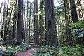 Founder's Grove
 Rider's point of view
 The park
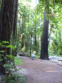 Chandler Grove
 Rockefeller Forest
See also

- Chandelier Tree
References
- 1 2 3 California Department of Transportation. "State Truck Route List". Sacramento: California Department of Transportation. Archived from the original (XLS file) on June 30, 2015. Retrieved June 30, 2015.
- ↑ http://www.arrs.net/HP_AvGMa.htm Avenue of the Giants Marathon
- ↑ Federal Highway Administration (March 25, 2015). National Highway System: California (North) (PDF) (Map). Scale not given. Washington, DC: Federal Highway Administration. Retrieved September 4, 2017.
- ↑ Natzke, Stefan; Neathery, Mike & Adderly, Kevin (June 20, 2012). "What is the National Highway System?". National Highway System. Washington, DC: Federal Highway Administration. Retrieved July 1, 2012.
- ↑ California State Legislature. "Section 260–284". Streets and Highways Code. Sacramento: California State Legislature. Retrieved June 9, 2017.
- ↑ California Department of Transportation (September 7, 2011). "Officially Designated State Scenic Highways and Historic Parkways". Sacramento: California Department of Transportation. Retrieved September 4, 2017.
- ↑ http://www.mdvaden.com/redwood_founders_tree.shtml
- ↑ Hawk, Diane (2004). Touring the old redwood highway : Humboldt County. Arcata, Calif.: Hawk Mountaintop Pub. p. 48. ISBN 0-9672162-4-9.
- ↑ California Department of Transportation (July 2007). "Log of Bridges on State Highways". Sacramento: California Department of Transportation.
- ↑ California Department of Transportation, All Traffic Volumes on CSHS, 2005 and 2006
External links
| Wikimedia Commons has media related to California State Route 254. |
Route map:
- California @ AARoads.com - State Route 254
- Caltrans: Route 254 highway conditions
- California Highways: SR 254
- The world-famous scenic drive is a 31-mile portion of old Highway 101.
- Photos of the Avenue