California State Route 158
| ||||
|---|---|---|---|---|
| June Lake Loop | ||||
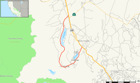 Map of Mono County in eastern California with SR 158 highlighted in red | ||||
| Route information | ||||
| Defined by Streets and Highways Code § 458 | ||||
| Maintained by Caltrans | ||||
| Length | 15.828 mi[1] (25.473 km) | |||
| Restrictions | Segment from June Lake north to June Lake Loop North Junction closed in winter | |||
| Major junctions | ||||
| South end |
| |||
| North end |
| |||
| Location | ||||
| Counties | Mono | |||
| Highway system | ||||
| ||||

State Route 158 (SR 158) is a scenic state highway in the U.S. state of California in Mono County.
Route description
The route is a loop west off of U.S. Route 395 passing through the community of June Lake, following the watercourse of June Lake, Gull Lake, Reversed Creek, Silver Lake, Rush Creek and Grant Lake, into the Mono Basin. The highway provides access to several vacation areas, trailheads, and scenic locations, including the June Mountain ski and snowboard resort.
SR 158 from 3.5 miles (5.6 km) north of June Lake to the northern junction with U.S. Highway 395 is closed during winters, typically from mid-December through mid-April.[2]
SR 158 is not part of the National Highway System,[3] a network of highways that are considered essential to the country's economy, defense, and mobility by the Federal Highway Administration.[4]
Major intersections
Except where prefixed with a letter, postmiles were measured on the road as it was in 1964, based on the alignment that existed at the time, and do not necessarily reflect current mileage. R reflects a realignment in the route since then, M indicates a second realignment, L refers an overlap due to a correction or change, and T indicates postmiles classified as temporary (for a full list of prefixes, see the list of postmile definitions).[1] Segments that remain unconstructed or have been relinquished to local control may be omitted. The entire route is in Mono County.
| Location | Postmile [1][5][6] | Destinations | Notes | ||
|---|---|---|---|---|---|
| June Lake Junction | 0.00 | South end of SR 158 | |||
| June Lake Loop North Junction | 15.84 | North end of SR 158 | |||
| 1.000 mi = 1.609 km; 1.000 km = 0.621 mi | |||||
See also

References
- 1 2 3 California Department of Transportation. "State Truck Route List". Sacramento: California Department of Transportation. Archived from the original (XLS file) on June 30, 2015. Retrieved June 30, 2015.
- ↑ "Mountain Pass Closures". California Department of Transportation.
- ↑ Federal Highway Administration (March 25, 2015). National Highway System: California (North) (PDF) (Map). Scale not given. Washington, DC: Federal Highway Administration. Retrieved September 24, 2017.
- ↑ Natzke, Stefan; Neathery, Mike & Adderly, Kevin (June 20, 2012). "What is the National Highway System?". National Highway System. Washington, DC: Federal Highway Administration. Retrieved July 1, 2012.
- ↑ California Department of Transportation (July 2007). "Log of Bridges on State Highways". Sacramento: California Department of Transportation.
- ↑ California Department of Transportation, All Traffic Volumes on CSHS, 2005 and 2006
External links
Route map:
| Wikimedia Commons has media related to California State Route 158. |