California State Route 124
| ||||
|---|---|---|---|---|
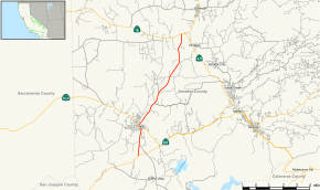 Map of Amador County in east central California with SR 124 highlighted in red | ||||
| Route information | ||||
| Defined by Streets and Highways Code § 424 | ||||
| Maintained by Caltrans | ||||
| Length | 10.33 mi[1] (16.62 km) | |||
| Major junctions | ||||
| South end |
| |||
|
| ||||
| North end |
| |||
| Location | ||||
| Counties | Amador | |||
| Highway system | ||||
| ||||

State Route 124 (SR 124) is a state highway in the U.S. state of California that runs from south of Ione to Route 16 near Waits Station in Amador County.
Route description
State Route 124 begins at SR 88 south of the city of Ione. SR 124 continues north as Church Street into the city of Ione, intersecting with Buena Vista Road and passing a lake along the way. Heading northward, SR 124 enters the downtown area of Ione, briefly running concurrently with SR 104 as Main Street before turning northwest as Plymouth Street. In Ione, the route passes a golf club to the west and a reservoir to the north, while heading towards the northeast. SR 124 runs slightly to the northeast as Plymouth Highway, crossing over several creeks, including Mule Creek, and bends slightly towards the east. The highway crosses Horse Creek and Dry Creek, and shortly before re-establishing a northerly route, it passes a mountain known as Rocky Point. SR 124 passes another peak before terminating at SR 16 northwest of Amador City at a T-shaped intersection.[2][3]
SR 124 is part of the California Freeway and Expressway System,[4] but is not part of the National Highway System,[5] a network of highways that are considered essential to the country's economy, defense, and mobility by the Federal Highway Administration.[6]
Major intersections
Except where prefixed with a letter, postmiles were measured on the road as it was in 1964, based on the alignment that existed at the time, and do not necessarily reflect current mileage. R reflects a realignment in the route since then, M indicates a second realignment, L refers an overlap due to a correction or change, and T indicates postmiles classified as temporary (for a full list of prefixes, see the list of postmile definitions).[7] Segments that remain unconstructed or have been relinquished to local control may be omitted. The entire route is in Amador County.
| Location | Postmile [7][1][8] | Destinations | Notes | ||
|---|---|---|---|---|---|
| | 0.00 | South end of SR 124 | |||
| Ione | 2.29 R5.96[N 1] | South end of SR 104 overlap | |||
| R5.77[N 1] R2.29 | North end of SR 104 overlap | ||||
| | R10.33 | North end of SR 124 | |||
1.000 mi = 1.609 km; 1.000 km = 0.621 mi
| |||||
See also

References
- 1 2 California Department of Transportation (April 2008). "Log of Bridges on State Highways". Sacramento: California Department of Transportation.
- ↑ California Road Atlas and Driver's Guide (Map). Thomas Brothers. 2008.
- ↑ Google (June 8, 2009). "Ione, California" (Map). Google Maps. Google. Retrieved June 8, 2009.
- ↑ California State Legislature. "Section 250–257". Streets and Highways Code. Sacramento: California State Legislature. Retrieved June 9, 2017.
- ↑ Federal Highway Administration (March 25, 2015). National Highway System: California (North) (PDF) (Map). Scale not given. Washington, DC: Federal Highway Administration. Retrieved September 30, 2017.
- ↑ Natzke, Stefan; Neathery, Mike & Adderly, Kevin (June 20, 2012). "What is the National Highway System?". National Highway System. Washington, DC: Federal Highway Administration. Retrieved July 1, 2012.
- 1 2 California Department of Transportation. "State Truck Route List". Sacramento: California Department of Transportation. Archived from the original (XLS file) on June 30, 2015. Retrieved June 30, 2015.
- ↑ California Department of Transportation, All Traffic Volumes on CSHS, 2007
External links
Route map:
| Wikimedia Commons has media related to California State Route 124. |