Cahuish
| Cahuish | |
|---|---|
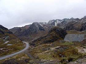 The southern slope of Cahuish(on the left) at the road above Qiruqucha | |
| Highest point | |
| Elevation | 4,900 m (16,100 ft) |
| Coordinates | 9°40′47″S 77°14′58″W / 9.67972°S 77.24944°WCoordinates: 9°40′47″S 77°14′58″W / 9.67972°S 77.24944°W |
| Geography | |
 Cahuish Location in Peru | |
| Location | Ancash, Peru |
| Parent range | Cordillera Blanca |
Cahuish[1][2] (possibly from Quechua qawi put into the sun)[3] is a mountain in the Cordillera Blanca in the Andes of Peru, about 4,900 metres (16,076 ft) high.[2] It is situated in the Ancash Region, Huari Province, Chavin de Huantar District, and in the Recuay Province, Ticapampa District. Cahuish lies southwest of the mountain and the archaeological site of Waraqayuq[4] and southeast of Yanamarey.[1][2]
References
- 1 2 Alpenvereinskarte 0/3b. Cordillera Blanca Süd (Peru). 1:100 000. Oesterreichischer Alpenverein. 2005. ISBN 3-937530-05-3.
- 1 2 3 Peru 1:100 000, Recuay (20-i). IGN (Instituto Geográfico Nacional - Perú).
- ↑ Teofilo Laime Ajacopa, Diccionario Bilingüe Iskay simipi yuyayk'ancha, La Paz, 2007 (Quechua-Spanish dictionary)
- ↑ Instituto Nacional de Cultura, Centro Nacional de Información Cultural, Contribución para un primer inventario general de sitios arqueológicos del Perú, Lima 2001
This article is issued from
Wikipedia.
The text is licensed under Creative Commons - Attribution - Sharealike.
Additional terms may apply for the media files.