Cacongo (municipality)
 | |
 Angola | |
| Location |
Ponta de Lândana Lândana Angola |
|---|---|
| Coordinates | 5°14′30″S 12°08′00″E / 5.241667°S 12.133472°E |
| Year first constructed | ~1950s[1] |
| Construction | masonry tower |
| Tower shape | quadrangular tower |
| Markings / pattern | white tower |
| Height | 8.8 metres (29 ft)[2] |
| Focal height | 60 metres (200 ft)[2] |
| Range | 9 nautical miles (17 km; 10 mi)[2] |
| Characteristic | Oc W 5s. [2] |
| Admiralty number | D4326[2] |
| NGA number | 25492[2] |
| ARLHS number | ANO-025)[1] |
| Managing agent | Instituto Marítimo e Portuário de Angola |
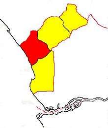
Cacongo[3] (ex-Lândana,[4] Concelho de Cacongo,[5] Malemba,[6] or Molembo[7]) is a municipality in Cabinda Province, an exclave of Angola. Its principal town is Cacongo. Landana lies on the coast of the Atlantic Ocean, adjacent to Landana Bay. The municipality covers 1,732 sq.km and had a population of 36,778 at the 2014 Census.
History
At the time of the arrival of the Portuguese in the 15th Century it was populated by the Kongo people and was the major portion of the Kingdom of Kakongo.[8]
See also
References
- 1 2 "Angola". The Lighthouse Directory. University of North Carolina at Chapel Hill. Retrieved 13 May 2017.
- 1 2 3 4 5 6 List of Lights, Pub. 113: The West Coasts of Europe and Africa, the Mediterranean Sea, Black Sea and Azovskoye More (Sea of Azov) (PDF). List of Lights. United States National Geospatial-Intelligence Agency. 2016.
- ↑ "Instituto Nacional de Estatística". Retrieved 2016-09-15.
- ↑ Lândana, Município (Approved) at GEOnet Names Server, United States National Geospatial-Intelligence Agency
- ↑ Cacongo, Concelho de (Variant) at GEOnet Names Server, United States National Geospatial-Intelligence Agency
- ↑ Malemba (Variant) at GEOnet Names Server, United States National Geospatial-Intelligence Agency
- ↑ "Map of the territories of Cabinda, Molembo and Massabi" edited by A. A. d’Oliveira. - Scale 1:750,000. - Lisbon: Commissão de Cartographia, 1886, engraved and printed in Paris, by Erhard Fres.
- ↑ "Maps Cabinda, Ngoyo, Kakongo, Loango". www.cabinda.net. Retrieved 2017-07-05.
Coordinates: 5°13′24″S 12°08′38″E / 5.22343°S 12.1439°E
This article is issued from
Wikipedia.
The text is licensed under Creative Commons - Attribution - Sharealike.
Additional terms may apply for the media files.