Cacoal Airport
| Capital do Café Airport Aeroporto Capital do Café | |||||||||||
|---|---|---|---|---|---|---|---|---|---|---|---|
 | |||||||||||
| Summary | |||||||||||
| Airport type | Public | ||||||||||
| Serves | Cacoal | ||||||||||
| Elevation AMSL | 249 m / 817 ft | ||||||||||
| Coordinates | 11°29′32″S 061°27′03″W / 11.49222°S 61.45083°WCoordinates: 11°29′32″S 061°27′03″W / 11.49222°S 61.45083°W | ||||||||||
| Map | |||||||||||
 OAL Location in Brazil | |||||||||||
| Runways | |||||||||||
| |||||||||||
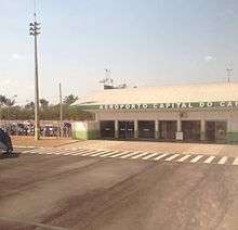
Capital do Café Airport (IATA: OAL, ICAO: SSKW) is the airport serving Cacoal, Brazil.
History
The airport was opened for traffic on June 2, 2009.[2] It was built as a replacement to an older facility located closer to downtown which was then closed.
Airlines and destinations
| Airlines | Destinations |
|---|---|
| Azul Brazilian Airlines | Cuiabá |
| Rimaa | Porto Velho |
a.^ Air taxi company operating regular charter flights.
Access
The airport is located 10 km (6 mi) from downtown Cacoal.
See also
References
- ↑ "Lista de aeródromos públicos" (in Portuguese). ANAC.
- ↑ "Portaria ANAC nº845/SIE" (PDF) (in Portuguese). ANAC. June 2, 2009. Archived from the original (PDF) on April 25, 2012. Retrieved December 4, 2011.
External links
- Airport information for SSKW at World Aero Data. Data current as of October 2006.Source: DAFIF.
- Airport information for SSKW at Great Circle Mapper. Source: DAFIF (effective October 2006).
- Current weather for SSKW at NOAA/NWS
- Accident history for OAC at Aviation Safety Network
This article is issued from
Wikipedia.
The text is licensed under Creative Commons - Attribution - Sharealike.
Additional terms may apply for the media files.