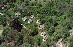
Cák
| Cák | ||
|---|---|---|
 | ||
| ||
 Cák Location of Cák | ||
| Coordinates: 47°21′16″N 16°30′53″E / 47.35456°N 16.51470°ECoordinates: 47°21′16″N 16°30′53″E / 47.35456°N 16.51470°E | ||
| Country |
| |
| County | Vas | |
| Area | ||
| • Total | 6.48 km2 (2.50 sq mi) | |
| Population (2004) | ||
| • Total | 282 | |
| • Density | 43.51/km2 (112.7/sq mi) | |
| Time zone | UTC+1 (CET) | |
| • Summer (DST) | UTC+2 (CEST) | |
| Postal code | 9725 | |
| Area code(s) | 94 | |
Cák is a village in Vas County, Hungary. It is 25 km away from Szombathely and 6 km North from Kőszeg.
History
In Cák graves have been found from Roman times. The earliest known reference to the village was from 1279 as Villa Chak. Turks destroyed the village in 1532, and Christian soldiers burned it down in 1573 and 1606.[1]
External links
- Street map (in Hungarian)
References
This article is issued from
Wikipedia.
The text is licensed under Creative Commons - Attribution - Sharealike.
Additional terms may apply for the media files.