County of Bute
| Bute | |
|---|---|
| Historic county | |
 | |
| Country | Scotland |
| County town | Rothesay |
| Area | |
| • Total | 225 sq mi (583 km2) |
| Ranked 30th of 34 | |
| Chapman code | BUT |
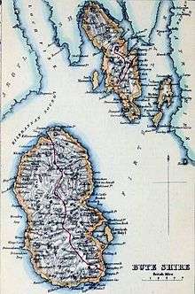
The County of Bute (Scottish Gaelic: Siorrachd Bhòid), also known as Buteshire,[1] is a historic county and registration county of Scotland.[2]
The county comprises a number of islands in the Firth of Clyde, between the counties of Argyll and Ayrshire, the principal islands being Bute, Arran, Great Cumbrae and Little Cumbrae. The county town is Rothesay, located on the Isle of Bute. Buteshire had its own elected county council from 1890 to 1975.
Local government councils
Buteshire had its own elected local government council from 1890 to 1975. However, in 1975 this system was superseded and Buteshire was divided for administrative purposes between the Strathclyde region districts of Argyll and Bute (which administered the Isle of Bute) and Cunninghame (which administered Arran and the Cumbraes). The Scottish regions were abolished in 1996, and this divide of the historic county continued, with both districts which administered historic Buteshire becoming council areas (Cunninghame under the name "North Ayrshire").
Parliamentary constituency
There was a Buteshire constituency of the House of Commons of the Parliament of Great Britain from 1708 to 1800 and of the Parliament of the United Kingdom from 1801 to 1918. Between 1708 and 1832 it was an alternating constituency with Caithness: one constituency elected a Member of Parliament (MP) to one parliament then the other elected an MP to the next. Between 1832 and 1918 it was a separate constituency, electing an MP to every parliament.
In 1918 the constituency was combined with the Ayrshire North constituency to form the Bute and Northern Ayrshire constituency, a constituency which straddled the boundary between the local government counties of Bute and Ayrshire.
In 1983, eight years after Scottish local government counties had been abolished, the Bute and Northern Ayrshire constituency was divided between the Argyll and Bute constituency and the Cunninghame North constituency.
In 2005, both constituencies were enlarged as part of the Fifth Periodic Review of Westminster constituencies.[3] The name "Argyll and Bute" was retained, while the enlarged Cunningham North was named North Ayrshire and Arran.
Constituencies with similar boundaries to the pre-2005 constituencies, and also called Argyll and Bute and Cunninghame North, are used by the Scottish Parliament.
Civil parishes
- North Bute
- Rothesay
- Kingarth
- Cumbraes or Great Cumbrae
- Kilbride, Arran
- Kilmory, Arran
- Lochranza
List of places
Towns and places in Bute include:[4]
- Ascog
- Blackwaterfoot
- Brodick
- Corrie, Arran
- Corriegills, Arran
- Dippen, Arran
- Kilchattan Bay, Bute
- Kildonan, Arran
- Kilmory, Arran
- Kingarth, Bute
- Kings Cross, Arran
- Lamlash
- Lochranza, Isle of Arran
- Machrie
- Millport, Cumbrae
- Mount Stuart
- Pirnmill
- Port Bannatyne, Bute
- Rothesay, Bute
- Sannox
- Shannochie
- Shiskine
- Sliddery
- Whiting Bay
See also
Gallery
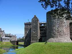 Rothesay Castle, with the 16th century forework in the centre, and the 13th century "Pigeon Tower" on the right
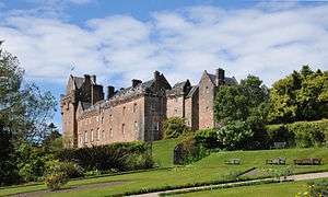
 Kilmory Castle is incorporated into Meikle Kilmory Farm, Bute
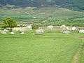 Machrie Moor Stone Circle
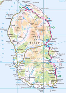 Isle of Arran
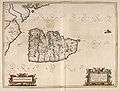 Blaeu Atlas. Arania
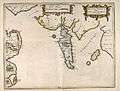 Blaeu Atlas. Buthe Insula
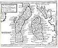 Shire of Bute. by H. Moll
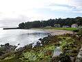 Kerrycroy Bay, Bute
 Ardbeg, Bute
References
- ↑

- ↑ "Land Register Counties", Leaflets, Registers of Scotland, archived from the original on 2010-02-02
- ↑ UK Parliament. The Parliamentary Constituencies (Scotland) Order 2005 as made, from legislation.gov.uk.
- ↑ "County Bute: List of towns and places", Registers of Scotland, Land Register, 2000, archived from the original on 2002-10-06
External links
- NLS map of Buteshire. John Thompson's Atlas of Scotland. 1832.
| Wikimedia Commons has media related to Buteshire. |
| Wikimedia Commons has media related to Towns and villages in Argyll and Bute. |
| Wikimedia Commons has media related to Great Cumbrae. |
| Wikimedia Commons has media related to Isle of Arran. |
| Wikisource has the text of the 1911 Encyclopædia Britannica article Bute (county). |