Bury Bridge
| Bury Bridge | |
|---|---|
 | |
| Coordinates | 51°02′12″N 3°30′24″W / 51.0367°N 3.5066°WCoordinates: 51°02′12″N 3°30′24″W / 51.0367°N 3.5066°W |
| Carries | Road |
| Crosses | River Haddeo |
| Heritage status | Ancient monument and Grade II* listed building |
| Characteristics | |
| Design | Arch bridge |
| Total length | 63 feet (19 m) |
| Width | 6 feet 10 inches (2.08 m) |
| No. of spans | 4 |
| History | |
| Construction end | Middle Ages |
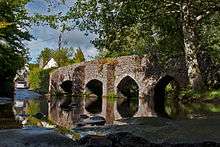
Bury Bridge at Bury in the parish of Brompton Regis within the English county of Somerset is a medieval packhorse bridge. It has been scheduled as an ancient monument and Grade II* listed building.[1][2]
The stone bridge carries a track over the River Haddeo. It consists of four spans, two of which are 7 feet (2.1 m), one 8 feet (2.4 m) and the other 10 feet (3.0 m). Two of the arches are pointed and the other two semi-circular.[1] It has a total span of 48 feet (15 m) and is 6 feet 6 inches (1.98 m) wide.[3]
References
| Wikimedia Commons has media related to Bury Bridge, Brompton Regis. |
- 1 2 "MSO8842 - Bury Bridge". Exmoor National Park Historic Environment Record. Exmoor National Park. Retrieved 7 March 2015.
- ↑ Historic England. "Bury Bridge at NGR SS 9445 2745 (1263985)". National Heritage List for England. Retrieved 4 April 2015.
- ↑ Hinchliffe, Ernest (1994). Guide to the Packhorse Bridges of England. Cicerone. p. 148. ISBN 978-1852841430.
This article is issued from
Wikipedia.
The text is licensed under Creative Commons - Attribution - Sharealike.
Additional terms may apply for the media files.