Burum, Friesland
| Burum Boerum | |||
|---|---|---|---|
| Village | |||
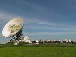 NSO-ground station | |||
| |||
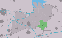 Location in the Kollumerland municipality | |||
 Burum Location in the Netherlands | |||
| Coordinates: Coordinates: 53°16′N 6°14′E / 53.267°N 6.233°E | |||
| Country |
| ||
| Province |
| ||
| Municipality |
| ||
| Population (2017) | |||
| • Total | 606 | ||
| Time zone | UTC+1 (CET) | ||
| • Summer (DST) | UTC+2 (CEST) | ||
| Postal code | 9851 | ||
| Telephone area | 0594 | ||


Burum (West Frisian language: Boerum) is a village in Kollumerland en Nieuwkruisland municipality, Friesland in the Netherlands.
It is the site of a ground station of the Dutch Nationale SIGINT Organisatie (national signals intelligence service), which intercepts satellite communications.[1][2] Burum also provides reference signals for Enhanced Automatic Frequency Correction, which help calibrates satellite communications.[3]
It had a population of 606 in January 2017.[4]
 Burum church
References
- ↑ "Nationale SIGINT Organisatie." (Archive) Ministry of Defence. Retrieved on 13 June 2013.
- ↑ "NATIONAL PROGRAMMES FOR MASS SURVEILLANCE OF PERSONAL DATA IN EU MEMBER STATES AND THEIR COMPATIBILITY WITH EU LAW" (PDF). European Parliament. 2013. p. 75. Archived from the original (PDF) on November 7, 2013.
The signals location in Burum and the analysis location in Eibergen, currently operated by the NSO, will stay active.
- ↑ Holland, Ian D (2018). "MH370 Burst Frequency Offset Analysis and Implications on Descent Rate at End-of-Flight". Ieee Aerospace and Electronic Systems Magazine. 33 (2): 24–33. arXiv:1702.02432. doi:10.1109/MAES.2018.170048.
- ↑ Inwonertal en info 2017 - Kollumerland
This article is issued from
Wikipedia.
The text is licensed under Creative Commons - Attribution - Sharealike.
Additional terms may apply for the media files.