Burnmoor Tarn
| Burnmoor Tarn | |
|---|---|
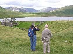 Overlooking Burnmoor Tarn with Burnmoor Lodge in the foreground. | |
| Location | Lake District |
| Coordinates | 54°25′41″N 3°15′34″W / 54.42814°N 3.25953°WCoordinates: 54°25′41″N 3°15′34″W / 54.42814°N 3.25953°W |
| Primary outflows | Whillan Beck |
| Catchment area | 6.02 km2 (2.32 sq mi) |
| Surface area | 23.9 ha (59 acres) |
| Max. depth | 13 m (43 ft) |
| Surface elevation | 253 m (830 ft) |
Burnmoor Tarn, on Eskdale Fell in Cumbria, England, is one of the largest entirely natural tarns in the Lake District. Its waters flow into Whillan Beck at the tarn's north-eastern corner, which immediately turns south and flows into Eskdale, joining the Esk at Beckfoot.[1] Burnmoor Lodge, a former fishing lodge, stands by the southern shore and a mediaeval corpse road runs past the eastern shore where it fords the beck.[2][3]
The tarn is one of the sites in DEFRA's UK Upland Waters Monitoring Network. It occupies 23.9 ha and lies at an altitude of 253 m in a moraine hollow on the uplands between Wastwater and Eskdale. The lake has two distinct basins close to the south-eastern shore and a maximum depth of 13 m. There are four main inflow streams to the north and north-west. The outflow at the eastern end joins the Hardrigg Beck which drains the slopes of Scafell and, in times of especially high flow, is partly diverted into the lake across a braided delta.[4]
References
- ↑ "Burnmoor Tarn". www.knowledge.me.uk. Retrieved 2015-04-23.
- ↑ "UK UWMN Sites". uwmn.defra.gov.uk. Retrieved 2015-04-23.
- ↑ "View: Cumberland LXXIX.NE (includes: Eskdale.) - Ordnance Survey Six-inch England and Wales, 1842-1952". maps.nls.uk. Retrieved 2015-04-23.
- ↑ "UK UWMN Sites". uwmn.defra.gov.uk. Retrieved 2015-04-23.