Burlington Historic District (Burlington, New Jersey)
|
Burlington Historic District | |
 | |
   | |
| Location | Roughly L-shaped, bounded by Delaware River and High, W. Broad, Albot, and Reed Sts., Burlington, New Jersey |
|---|---|
| Coordinates | 40°4′43″N 74°51′50″W / 40.07861°N 74.86389°WCoordinates: 40°4′43″N 74°51′50″W / 40.07861°N 74.86389°W |
| Area | 31 acres (13 ha) |
| Architect | William Strickland; Richard Upjohn |
| Architectural style | Gothic, Gothic Revival |
| NRHP reference # | 75001124[1] |
| NJRHP # | 758[2] |
| Significant dates | |
| Added to NRHP | March 13, 1975 |
| Designated NJRHP | July 1, 1974 |
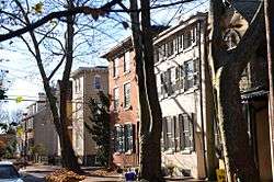
The Burlington Historic District in Burlington, New Jersey, is historic district bounded by the Delaware River and High, West Broad, Talbot, and Reed Streets listed on state and federal registers of historic places.[2][3] The oldest building in Burlington County and one of the oldest residences in New Jersey, the Revell House, is contributing property. St. Mary's Episcopal Church is also within the district, which adjacent to the city's High Street Historic District.[3]
See also
References
- ↑ National Park Service (2010-07-09). "National Register Information System". National Register of Historic Places. National Park Service.
- 1 2 "New Jersey and National Registers of Historic Places". New Jersey Department of Environmental Protection - Historic Preservation Office. Retrieved 2016-01-19.
- 1 2 Historic District Map City of Burlington June 17, 2014
External links
This article is issued from
Wikipedia.
The text is licensed under Creative Commons - Attribution - Sharealike.
Additional terms may apply for the media files.