Rötteln Castle
| Rötteln Castle (Burg Rötteln) | |
|---|---|
| Lörrach, Baden-Württemberg, Germany | |
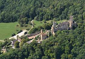 Aerial view at Rötteln Castle | |
| Type | Castle |
| Site information | |
| Owner | Government of Baden-Württemberg |
| Open to the public | yes (March–October) |
| Condition | Ruins survive |
| Site history | |
| Built | c. 11th century |
| Built by | Lords of Rötteln |
| In use | 1000's–1678 |
| Materials | Stone (11th century architecture) |
| Demolished | 29 June 1678 |
| Battles/wars |
Thirty Years War Franco-Dutch War |
| Events | 1356 Basel earthquake |
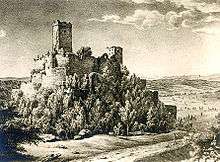
Rötteln Castle (German: Burg Rötteln), located above the Lörrach suburb of Haagen, lies in the extreme southwest corner of the German state of Baden-Württemberg just 10 kilometres (6 miles) north-east of the Swiss City of Basel. The fortification was one of the most powerful in the southwest, and today is the third largest castle ruin in Baden.[1]
The ruins of the castle are situated on a widely visible forested hill 422 metres (1,385 ft) above sea level. The keep lies on a spur projecting from the steep sided east side of the lower Wiese valley.
History
The castle has probably existed since the beginning of the 11th century. In 1102 is the first documented mention of a lord of Rötteln, one Dietrich von Rötteln, the bailiff of St. Albans near Basel. This year is also considered the date of the founding of the city of Lörrach. In 1204 Dietrich III of Rötteln died, having amassed a large holding in the Wiese valley. His sons held high offices; Walter I was the Kapitular (a priest who is authorized to say the mass in a cathedral and perform other duties of a bishop) of Konstanz and Basel, Luithold I was the bishop of Basel, Konrad I was the founder of the city of Schopfheim, which was important to the later formation of the Markgräflerland. The first documented mention of the castle itself is from the year 1259.
Luithold II von Rötteln, the last male of his line, gave the lordship of Rötteln to the Margrave Rudolf I of Hachberg-Sausenberg and his heiress Agnes von Rötteln in the year 1311. As a result, the Margrave of Hachberg-Sausenberg, also became lord of the former domain of Rötteln. The Margrave then moved from Sausenburg Castle to Rötteln Castle to more easily administer his new domain and appointed a bailiff to oversee Sausenburg.
Luithold II von Rötteln died on May 19, 1316, and the passing of Rötteln to Hachberg-Sausenburg was an important step in the eventual formation of the Markgräflerland. In 1332 the castle was besieged by the people of Basel because the Margrave Rudolf II stabbed the mayor of Basel during an argument. The conflict was resolved at the last moment through an agreement to settle the argument. Arrowheads, crossbow bolts, and other finds near the castle attest to this siege.
The Basel earthquake of 1356 destroyed large portions of the city, and the castle suffered severe damage.
In 1444 the domain of Badenweiler passed from the last Count of Freiburg, John, to the son of Margrave Wilhelm, Rudolf IV von Hachberg-Sausenberg. The combination of the three dominions, Rötteln, Sausenburg, and Badenweiler formed the foundation of the Markgräflerland.
In 1503 the castle came into the possession of the Margrave of Baden. In 1525 (during the German Peasants' War) revolting peasants briefly took possession of the castle.
From 1618 to 1648 during the Thirty Years War the castle was occupied by both Swedish and Imperial forces.
During the Franco-Dutch War, on June 29, 1678, the castles of Rötteln, Sausenburg, and Badenweiler were destroyed by the army of the French Marshall François de Créquy. The castle ruins were thereafter used as a source of building stone (quarry).
The Black Forest Society of Baden(Schwarzwaldverein) began to survey the ruins in 1884 in order to preserve it. Since 1926 this has been the concern of the Röttelnbund e.V. club based in Lörrach-Haagen. Today the ruins have been restored to approximately their condition after their destruction in 1678.
Location
The site of the castle extends from northwest to southwest over a distance of almost 300 meters. The widely spread castle can be roughly divided into the fore-castle and upper castle. To the west a bastion-like point extends for the placement of light artillery. Passage from the fore-castle to the upper castle is by means of a drawbridge. The upper castle with its powerful keep is the oldest part of the castle. Archaeological finds from the castle and grounds are on display in the museum in the courtyard of the castle.
The „Kapf“, the bastion and the south-gate[2]
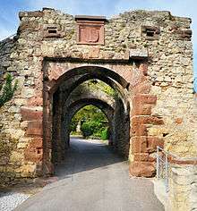
The free place called "Kapf" in front of the entrance to the south-gate served as a meeting place for the regional court, the court of appeals for the village courts. The provincial governor had the presidency. He was assisted by the “Landschreiber” (deputy of the provincial governor and first law officer) and seven "free men" as judges. They came from the respected families of the territorial estates (early democratic institution with some rights of self-government). The death sentences which had been pronounced by the regional court were promptly executed on the “Kapf”. After 1503 the Margraves of Baden converted the “Kapf” to a bastion formed as a star-shaped redoubt. On French orders, the bastion had to be dragged (destroyed) in January 1689. The stones were used by the French to build their fortress at Huningue (on the left bank of the river Rhein just before the city of Basle).
Via the South Gate you enter the outer bailey. A part of the deeply staggered gatehouse consisting of three gates, was also a tower. The apex of the portal contains a slab with the coat of arms of the builder-owner, Marquis Rudolf IV of Hachberg-Sausenberg (today just a copy). It is marked with the date 1468. The original of the coat of arms and the court table of the “Kapf“ are exhibited in the Dreiländermuseum Lörrach.
The outer bailey[2]
The outer bailey or lower castle was developed in the 14th and 15th centuries, but already in former times there was a farmstead belonging to the castle at this place. The outer bailey was surrounded by a high ring wall with flanking towers. On the west side, the defense system is well preserved. The area inside the wall was densely built with a broad lane halfway through. The farmstead, the administration and the garrison with up to 300 mercenaries from all over Europe have characterized the overall picture. The farmstead, storage buildings and lodgings for maids, servants, craftsmen and their families made a fortified village out of the outer bailey.
As early as 1377, a document mentions an innkeeper living in the outer bailey. The inhabitants of the castle, artisans, peasants and travelers were invited to make a stop at the inn. Today's “Café” is a modern building, but it is probably situated on the site of the medieval inn.
To the east, on the way to the inner bailey, there is the so-called “Landschreiberei”. Locally it was the most important institution of the administration of the Marquis of Baden. Here the office and the archive were housed and the local officers acting here kept in touch with the remote residence in Durlach (today Karlsruhe-Durlach). The striking four-storey building dates back to the Late Middle Ages. It was rebuilt by the “Röttelnbund” until 1985, and now houses event locations, archive and museum as well as the kiosk in the entrance area.
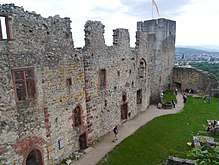
Access to the inner bailey (upper castle)[2]
There is no other castle in the surrounding area in which the sophisticated access technology has been preserved that visibly. The upper or main castle is the heart of the whole system; it was therefore specially protected. The upper castle is totally enclosed by a curtain wall with a defense walk. In addition a moat was created by removing the bedrock in between the Inner bailey and Outer bailey. At this place, a wooden bridge spans the moat, because here is the only passage through the curtain wall in the upper castle.
Once the moat was very deep, and the connection between the lower and the upper castle was provided by a drawbridge. The old support pillars of the drawbridge still carry today's bridge of steel.
In addition to the main gate, the narrow "manhole" (today closed by a grid) grants access to individuals. This access was also backed up by a drawbridge. Above the apex of the main gate there is a sandstone slab showing the coat of arms of the builders and powerful owners of the castle, the Margraves (Marquises) of Hachberg-Sausenberg.
Behind the main gate there are huge windowless walls. To enter the inner bailey (upper castle) you have to pass the safety-installations consisting of three gates. From the mighty curtain-wall on the left, the so-called "Giller" rises as a gate defense tower.
Cellar under the „Old Building“ (Manor House)[2]
A castle is not only the ancestral home of a noble family and a center of power, but also the heart of an economic enterprise. From here, the widely scattered property was operated and managed. The alimentation of the numerous inhabitants of the castle had to be ensured. And even in the case of a long-lasting siege, the people at the castle had to be fed and cared for. Adequate storage was therefore indispensable. Large cellar rooms for storage were built within the castle.
Under the "Old Building" (Manor house) is the large wine cellar with a mighty vault. Originally, the cellar had a simple wood-beamed ceiling. In the second half of the 14th century Margrave Rudolf III carried out major reconstruction work on the "Old Building". Probably it was on this occasion that the wooden ceiling of the cellar was replaced by the barrel vault.
„Giller“ and cistern[2]
The tower named “Giller” secured the only entrance to the upper castle – especially before the expansion of the outer ward (lower castle). At times, he served as well as the keep as a prison tower.
When cleanup inside parts of jougs (iron collar), footcuffs, handcuffs and stone weights have been found.
Originally the "Giller" was significantly lower. During reconstruction work in 1926 a storey with battlements made of concrete was added.
The cistern is already mentioned in 1420 and was called "deep castle well." Since the water-bearing layers of bedrock are in very great depth, surface water was collected in the cistern.
The "deep castle well" is one of the rare cisterns of this kind in southern Germany. The 8 to 10 meters deep shaft was surrounded by a sheath of gravel and sand and sealed with a clay layer to the outside. Incoming surface water seeping through the filter material into the interior of the shaft and into the cistern. The water in the "deep castle well" had an exceptionally good quality.
Palas (manor house) and castle chapel[2]
The Palas was the residence of the rule and at the same time representative building. It was built in three phases: In the south rises the so-called “Old building”, on the north side an intermediate building is attached and close to the keep there is the “New construction”.
The Palas has three floors, but only the top floor went through all three phases of construction. It is clearly visible that the "Old building" was extended first and later on increased.
The "old building" dates back to the time of the noble lords of Rötteln (13th century). Downstairs there is the Knights' Hall, where social life was happening. Above the Knights' Hall the living and sleeping areas were located. In the intermediate building the kitchen was housed.
The "new construction" was built under the reign of Margrave (Marquess or Marquis) Philip of Hachberg-Sausenberg (1454-1503). The keystone of the entrance portal is decorated with the coat of arms of the Marquis and his wife Maria of Savoy (1455-1511).
On the top floor the spacious ballroom occupied the entire area. In the niches of the large windows are benches. The embrasure of windows and portals of the "new building" show exceptionally fine designs. They bear witness to the demanding need for representation of the Marquis, who belonged to the Burgundian and later on to the French court. The new building was comfortable. There were numerous smaller rooms that were heated with tiled stoves. Part of the comfort were also the toilet facilities on the eastern exterior wall.
The chapel of St. Mary (consecrated 1504) on the north side of the bailey was an elongated hall with two columns in the center axis, which supported a ribbed vaulting in late Gothic style.
It can be assumed that the burial place of Margrave Rudolf IV (D. 1487) was within the chapel.
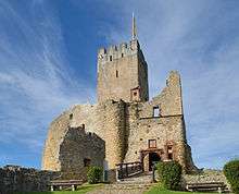
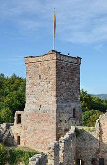
The keep (Bergfried)[2]
The Bergfried stands on the highest point of the castle. Its construction dates back to the early days of the castle among the free nobles of Rötteln, and may be even older. The original entrance is located on the south side on the level of the third floor of the tower. It was only accessible via ladders or a wooden staircase. The current entrance is modern.
The Bergfried was a watchtower, retreat for the defense case and prison tower at the same time. Along with the curtain wall on the mountain side and the neck ditch he formed the most important element in the defense system of the first castle.
The processing of the stones changes with increasing height and bears witness to a prolonged construction period. On the lower layers of stone is a remarkable structure of the surface which otherwise is only found in the Romanesque church – for castles this is unique in the region of Baden.
From the top of this tower there is a magnificent view over the castle, into the valley of the river Wiese, to the Black Forest, the Swiss Jura and the Alsatian Vosges mountain range and sometimes even the Bernese Alps.
Furnishing and inventory
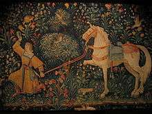
Due to the castle's former representative character, it is assumed that the interior was also decorated splendidly and expensively. This is what pilgrim Hans von Waltheim from Halle an der Saale[3] states, having visited the castle on July 9, 1474, in the course of his return trip. Walter marvelled especially at the tapestries in the cabinet. He wrote:[4]
[…] That was the most beautiful workmanship of pictures, of countenance, of clothing, of animals and flowers and other work, as if it lived, of which I haven't seen many. […]
The luxurious furnishing such as tapestry and fireplaces lead back to the sumptuous and large-dimensioned rooms, especially inside of the palas. The ballroom-like room was difficult to heat - this is why carpets were attached to the cold walls, creating a certain warmth. Smaller rooms were panelled with wood.[5]
Additional evidence of the sophisticated and comfortable inventory can be seen in the stove tiles which are exhibited in the castle's museum and the Dreiländermuseum in Lörrach, which is a museum dedicated to bringing near the history, differences and similarities of the border region including Germany, France and Switzerland. In the 14th century, chimney- and fireplace-building were as progressed as it was possible for large-scale tiles to store a specific amount of heat. This allowed a more even and widespread heating. Besides the ovens made of clay, others were made of cast-iron which could both absorb and emit the heat even faster. Findings have shown that Rötteln Castle has been equipped with at least 10-15 masonry heaters. Many of them dated back to the time of Rudolf IV. and Philip who imported them from Burgundy and Romandy.[6] Some tiles carry highly artistic ornaments and reliefs with biblical scenes.[7]
Rötteln castle was also equipped with own workshops dedicated to the production of furniture. It is also historically confirmed that a known Burgundian tapestry craftsman produced tapestries there.[6]
During restoration work, many different findings have been made. These include round shots, arrowheads and other either completely or partially preserved weapons but also items of daily life such as harnesses, buttons, tools, desk bells and door locks. Findings and historic illustrations which show the castle's history are exhibited at the museum of the castle.[8]
The majority of the findings -including the most valuable ones- are exhibited at the Dreiländermuseum in Lörrach. These include tiles, glassware, fragments of tableware, tools, parts of weapons, pipes, a chessman, a judge's table along with an executioner's sword and different instruments of torture.[9]
Usage today

The castle ruin is open throughout the year and tours can be arranged in advance. While the lower castle can be visited anytime for free, the upper castle has different, seasonal opening hours. In addition to a museum in the reconstructed district offices a tavern can be found inside the fortifications. The castle is federal state-owned and is being maintained by the institution Staatliche Schlösser und Gärten Baden-Württemberg. Both the upkeep and the sustentation rest on the Röttelnbund e.V.. The upper castle is visited by nearly 50.000 visitors annually.[10] The tavern and the pub garden belong to the city of Lörrach which leases both trades to private persons. Since December 2017, they run a café.[11] The registry office of Lörrach operates a wedding hall within the reconstructed district offices. The so-called Knechtstube ("servant's parlour") can seat 25 people.[12][13] Around 25 weddings take place every year.[14]
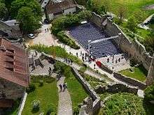
Since 1968, the society Burgfestspiele Rötteln (open-air theatre festival that takes place within the grounds of a castle ) performs classic plays on the outdoor stage in the outer bailey every year. Since 2007, another festival called Jazz auf der Burg[15]("Jazz at the castle") takes place and is being supported by the Jazz-Club 56.[16] In summer 2003, an open-air cinema was mounted.[17]
Since 1938, Rötteln Castle and environment is acknowledged as conservation area. The short description said: "Very remarkable, large castle ruin within scenically excellent location and environment, especially arboretums, bushes, meadows, forest border."[18]
Bibliography
See also
Notes
- ↑ SWR Fernsehen: Fahr mal hin - Eine Stadt im Dreiländereck
- 1 2 3 4 5 6 7 description based on official German explanation boards on site prepared by the state heritage agency Staatliche Schlösser und Gärten
- ↑ Albert Werminghoff: Das oberbadische Land im Pilgerbuche des Hans von Waltheim aus dem Jahre 1474/75 in: Zeitschrift für die Geschichte des Oberrheins, 1922, Vol. 76 / NF 37, p. 71–82.
- ↑ Sophie Stelzle-Hüglin: Wohnkultur auf Burg Rötteln. Ofenkeramik aus Gotik und Renaissance. p. 637
- ↑ Krüger: Burg Rötteln. p. 24
- 1 2 Krüger: Burg Rötteln. p. 27
- ↑ Ofenkacheln von der Burg Rötteln, retrieved on September 12, 2013
- ↑ Krüger: Burg Rötteln. p. 42–44
- ↑ Sammlung Burg Rötteln im Dreiländermuseum, retrieved on September 11, 2013
- ↑ according to internal statistics of the Röttelbund 2007-2015; annual average 48724; the outer bailey along with the pub garden is visited by many more visitors.
- ↑ Willi Adam: Aus der Burgschenke Rötteln in Lörrach wird "Fräulein Burg". In: Badische Zeitung, 18 October 2017
- ↑ Badische Zeitung: Im Trauzimmer gerne altmodisch, by Katharina Bartsch, 3 August 2013, retrieved on 18 September 2013
- ↑ Heiraten in Lörrach, retrieved on 18 September 2013
- ↑ news-aus-baden.de:Ja-Wort auf Burg Rötteln ein Erfolg, 11 January 2006, retrieved on 18 September 2013
- ↑ Website of the festical
- ↑ Website of the Jazztone Archived 2016-10-24 at the Wayback Machine.
- ↑ Südkurier: Filmfestival auf der Burg, 13 August 2003, retrieved on 8 September 2013
- ↑ Fact file of the protected landscape in the index of protected areas published by the Baden-Württemberg Office for the Environment, Survey and Conservation (Landesanstalt für Umwelt, Messungen und Naturschutz Baden-Württemberg)
External links
| Wikimedia Commons has media related to Rötteln Castle. |
| Wikivoyage has a travel guide for Rötteln Castle. |
- English information about Rötteln Castle on the Homepage of the state heritage agency Staatliche Schlösser und Gärten
- English information about Rötteln Castle on the Homepage of Basel Tourism
- English information about Rötteln Castle on the Homepage of the City of Lörrach
- English information about Rötteln Castle on the Homepage alamanicus.com
- Burgfestspiele Rötteln (in German)
- Burg Rötteln: Image gallery
- Burg Rötteln at the site Burgenwelt.de/ (in German)
- Historical information (in German)
Coordinates: 47°38′18″N 07°40′05″E / 47.63833°N 7.66806°E