Bundey, South Australia
| Bundey South Australia | |||||||||||||||
|---|---|---|---|---|---|---|---|---|---|---|---|---|---|---|---|
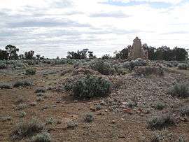 The ruins of the Immanuel Lutheran Church at Bundey, which was last used in 1925 | |||||||||||||||
 Bundey | |||||||||||||||
| Coordinates | 33°53′S 139°18′E / 33.89°S 139.30°ECoordinates: 33°53′S 139°18′E / 33.89°S 139.30°E | ||||||||||||||
| Postcode(s) | 5320 [1] | ||||||||||||||
| LGA(s) | Regional Council of Goyder [1] | ||||||||||||||
| State electorate(s) | Stuart [1] | ||||||||||||||
| Federal Division(s) | Grey [1] | ||||||||||||||
| |||||||||||||||
Bundey is a locality in the Mid North region of South Australia. It is located on Goyder's Line, on the plains between Burra and Morgan in the Regional Council of Goyder.[1] The bounded locality of Bundey corresponds to the boundaries of the cadastral Hundred of Bundey, except for the southwestern corner of the Hundred which is the northeastern corner of the locality of Geranium Plains.[2] Bundey was named in 1878 for politician William Henry Bundey.[2]
The area was originally the territory of the Ngadjuri people.[3] Following European settlement, it was surveyed into 500 acre blocks and taken up by farmers in 1879.[4] Bundey Post Office opened on 1 May 1882 and closed on 1 October 1901.[5]
Bundey Immanuel Lutheran Church was established in 1889. The first building was pug and daub. After storm damage, a more substantial building of limestone and bricks replaced it in either 1900 or 1905.[6] The church building also served as a school during the week, with lessons in a mixture of German and English, until its forced closure by the state government in 1917.[7][8] The church itself closed in January 1925, and the building is now an abandoned ruin.[9]
See also
References
- 1 2 3 4 5 "Bundey, 5320". Location SA Map Viewer. Government of South Australia. Retrieved 19 February 2016.
- 1 2 "Placename Details: Bundey (LOCB)". Property Location Browser. Land Services, Government of South Australia. SA0049413. Retrieved 19 February 2016.
- ↑ Emmaus to Worlds End: a history of the Robertstown Council Area. "The Area - Its Settlement and Development": District Council of Robertstown. 1986.
- ↑ Emmaus to Worlds End: a history of the Robertstown Council Area. "Districts: Bundey": District Council of Robertstown. 1986.
- ↑ "Bundey". Post Office Reference. Premier Postal. Retrieved 27 November 2016.
- ↑ "BUNDEY IMMANUEL LUTHERAN CHURCH 1881 - 1925" (PDF). Gustav's Newsletters. Eudunda Family Heritage Gallery. September 2001. p. 4. Retrieved 19 February 2016.
- ↑ P.H. Colliver. Freedom Found, A History of the Altus Family in Australia. Adelaide: LPH. pp. 115, 127. ISBN 0 9592754 0 1.
- ↑ Emmaus to Worlds End: a history of the Robertstown Council Area. "Schools: Bundey Lutheran School": District Council of Robertstown. 1986.
- ↑ Emmaus to Worlds End: a history of the Robertstown Council Area. "Churches: Bundey Lutheran": District Council of Robertstown. 1986.
Further reading
- the booklet “Bundey Immanuel Lutheran Church” compiled and published by Betty Dreckow and Clem Jaensch.
| Wikimedia Commons has media related to Bundey, South Australia. |