Bun Sruth
| Bun Sruth | |
|---|---|
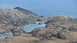 The loch of Bun Sruth | |
| Location | South Uist Scotland |
| Coordinates | 57°06′41″N 7°13′08″W / 57.1115°N 7.2189°WCoordinates: 57°06′41″N 7°13′08″W / 57.1115°N 7.2189°W |
| Type | loch |
| Max. length | 70 yards (64 m) |
Bun Sruth is a small loch about 70 yards (64 m) in length[1] at the southeast extremity of the island of South Uist in the Outer Hebrides of Scotland. It is surrounded by hills and is connected to the sea by a narrow passage between cliffs of sheer rock.[2]
Access
The only access to Bun Sruth is on foot or by boat.[2] From the sea the narrow tidal gorge is difficult to find, and difficulties in negotiating the channel can arise from the fast tidal flow and from seaweed which prevents the use of a propeller.[3] At low tide the water level in the loch is higher than sea level, and drains over a rock shelf in the entrance,[2] making entrance by boat impossible until the tide has risen at least seven feet.[1] Exit by boat is thus best undertaken just after high tide.[2]
Wildlife
The valley contains some ruins of croft houses, but the area is now inhabited only by sheep and wildlife.[2] Pollock may be found in the loch,[3] and both sea trout and salmon have been reported.[1] Fishing vessels have been known to take shelter in the loch.[1]
References
- 1 2 3 4 United States. Hydrographic Office (1917). Publications. Retrieved 11 August 2011.
- 1 2 3 4 5 Richenda Miers (1 September 2006). Scotland. New Holland Publishers. p. 519. ISBN 978-1-86011-339-0. Retrieved 11 August 2011.
- 1 2 "Zims Drascombe Longboat". Arkitrek. 29 June 2008. Archived from the original on 29 March 2012. Retrieved 11 August 2011.