Bullock, North Carolina
| Bullock, North Carolina | |
|---|---|
| Unincorporated community | |
 Bullock  Bullock | |
| Coordinates: 36°29′29″N 78°32′42″W / 36.49139°N 78.54500°WCoordinates: 36°29′29″N 78°32′42″W / 36.49139°N 78.54500°W | |
| Country | United States |
| State | North Carolina |
| County | Granville |
| Elevation | 427 ft (130 m) |
| Time zone | UTC-5 (Eastern (EST)) |
| • Summer (DST) | UTC-4 (EDT) |
| ZIP code | 27507 |
| Area code(s) | 919 |
| GNIS feature ID | 1023862[1] |
Bullock is an unincorporated community in Granville County, North Carolina, United States. The community is located on U.S. Route 15 3.3 miles (5.3 km) north-northeast of Stovall and 12.7 miles (20.4 km) north-northeast of Oxford. Bullock has a post office with ZIP code 27507.[2][3]
References
- ↑ "Bullock". Geographic Names Information System. United States Geological Survey.
- ↑ United States Postal Service (2012). "USPS - Look Up a ZIP Code". Retrieved February 8, 2015.
- ↑ "Postmaster Finder - Post Offices by ZIP Code". United States Postal Service. Retrieved February 8, 2015.
Municipalities and communities of Granville County, North Carolina, United States | ||
|---|---|---|
| Cities | 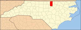 | |
| Towns | ||
| Unincorporated communities | ||
This article is issued from
Wikipedia.
The text is licensed under Creative Commons - Attribution - Sharealike.
Additional terms may apply for the media files.