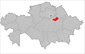
Bukhar-Zhyrau District
| Bukhar-Zhyrau | ||
|---|---|---|
| District | ||
| Бұқар жырау ауданы | ||
| ||
 | ||
| Country | Kazakhstan | |
| Region | Karaganda Region | |
| Administrative center | Botakara | |
| Founded | 1938 | |
| Area | ||
| • Total | 5,628 sq mi (14,576 km2) | |
| Population (2013)[1] | ||
| • Total | 63,236 | |
| Time zone | UTC+6 (East) | |

Bukhar-Zhyrau District (Kazakh: Бұқар жырау ауданы) is a district of Karaganda Region in central Kazakhstan. The administrative center of the district is the settlement of Botakara.[2] Population: 63,236 (2013 estimate);[1] 64,003 (2009 Census results);[3] 69,617 (1999 Census results).[3]
References
- 1 2 "Население Республики Казахстан" (in Russian). Департамент социальной и демографической статистики. Retrieved 27 December 2013.
- ↑ www.geonames.de Subdivisions of Kazakhstan in local languages
- 1 2 "Население Республики Казахстан" (in Russian). Департамент социальной и демографической статистики. Retrieved 8 December 2013.
Capital: Karaganda | ||
| Districts | 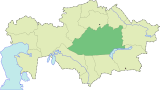 | |
| Major cities | ||
Coordinates: 48°45′49″N 73°40′20″E / 48.76361°N 73.67222°E
This article is issued from
Wikipedia.
The text is licensed under Creative Commons - Attribution - Sharealike.
Additional terms may apply for the media files.