Buchanan, Georgia
| Buchanan, Georgia | |
|---|---|
| City | |
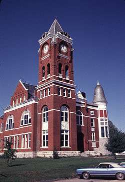 Former Haralson County courthouse in Buchanan, now the Buchanan-Haralson Public Library | |
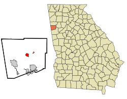 Location in Haralson County and the state of Georgia | |
| Coordinates: 33°48′6″N 85°11′1″W / 33.80167°N 85.18361°WCoordinates: 33°48′6″N 85°11′1″W / 33.80167°N 85.18361°W | |
| Country | United States |
| State | Georgia |
| County | Haralson |
| Named for | James Buchanan |
| Area | |
| • Total | 1.7 sq mi (4.4 km2) |
| • Land | 1.5 sq mi (3.8 km2) |
| • Water | 0.2 sq mi (0.5 km2) |
| Elevation | 1,243 ft (379 m) |
| Population (2010) | |
| • Total | 1,104 |
| • Estimate (2016)[1] | 1,141 |
| • Density | 745/sq mi (287.8/km2) |
| Time zone | UTC-5 (Eastern (EST)) |
| • Summer (DST) | UTC-4 (EDT) |
| ZIP code | 30113 |
| Area code(s) | 770 |
| FIPS code | 13-11616[2] |
| GNIS feature ID | 0354892[3] |
| Website |
buchananga |
Buchanan is a city in Haralson County, Georgia, United States. The population was 1,104 at the 2010 census,[4] up from 941 at the 2000 census. The city is the county seat of Haralson County.[5]
Locally, the city's name is pronounced Buck-HAN-uhn.
History
Buchanan was founded in 1856 as seat of the newly formed Haralson County. It was named for United States President James Buchanan.[6] Buchanan was incorporated as a town in 1857 and as a city in 1902.[7]
Geography
Buchanan is located just east of the center of Haralson County at 33°48′6″N 85°11′1″W / 33.80167°N 85.18361°W (33.801726, -85.183506).[8] U.S. Route 27 bypasses the city to the east, leading north 16 miles (26 km) to Cedartown and south 6 miles (10 km) to Bremen.
According to the United States Census Bureau, Buchanan has a total area of 1.7 square miles (4.4 km2), of which 1.5 square miles (3.8 km2) are land and 0.2 square miles (0.5 km2), or 12.42%, are water.[4]
Demographics
| Historical population | |||
|---|---|---|---|
| Census | Pop. | %± | |
| 1880 | 158 | — | |
| 1890 | 324 | 105.1% | |
| 1900 | 359 | 10.8% | |
| 1910 | 462 | 28.7% | |
| 1920 | 491 | 6.3% | |
| 1930 | 429 | −12.6% | |
| 1940 | 504 | 17.5% | |
| 1950 | 651 | 29.2% | |
| 1960 | 753 | 15.7% | |
| 1970 | 800 | 6.2% | |
| 1980 | 1,019 | 27.4% | |
| 1990 | 1,009 | −1.0% | |
| 2000 | 941 | −6.7% | |
| 2010 | 1,104 | 17.3% | |
| Est. 2016 | 1,141 | [1] | 3.4% |
| U.S. Decennial Census[9] | |||
As of the census[2] of 2000, there were 941 people, 345 households, and 221 families residing in the city. The population density was 638.6 people per square mile (247.2/km²). There were 380 housing units at an average density of 257.9 per square mile (99.8/km²). The racial makeup of the city was 87.14% White, 11.37% African American, 0.11% Native American, 0.11% Asian, 0.11% from other races, and 1.17% from two or more races. Hispanic or Latino of any race were 0.53% of the population.
There were 345 households out of which 27.0% had children under the age of 18 living with them, 46.1% were married couples living together, 14.8% had a female householder with no husband present, and 35.7% were non-families. 33.6% of all households were made up of individuals and 17.7% had someone living alone who was 65 years of age or older. The average household size was 2.38 and the average family size was 3.02.
In the city, the population was spread out with 22.8% under the age of 18, 8.0% from 18 to 24, 28.5% from 25 to 44, 21.5% from 45 to 64, and 19.2% who were 65 years of age or older. The median age was 38 years. For every 100 females, there were 96.9 males. For every 100 females age 18 and over, there were 86.2 males.
The median income for a household in the city was $23,269, and the median income for a family was $26,964. Males had a median income of $24,205 versus $16,458 for females. The per capita income for the city was $11,821. About 20.5% of families and 22.7% of the population were below the poverty line, including 23.4% of those under age 18 and 19.8% of those age 65 or over.
Education
Haralson County School District
The Haralson County School District holds pre-school to grade twelve, and consists of four elementary schools, a middle school, and a high school.[10] The district has 231 full-time teachers and over 3,766 students.[11]
- Buchanan Elementary School
- Buchanan Primary School
- Tallapoosa Primary School
- West Haralson Elementary School
- Haralson County Middle School
- Haralson County High School
References
- 1 2 "Population and Housing Unit Estimates". Retrieved June 9, 2017.
- 1 2 "American FactFinder". United States Census Bureau. Archived from the original on 2013-09-11. Retrieved 2008-01-31.
- ↑ "US Board on Geographic Names". United States Geological Survey. 2007-10-25. Retrieved 2008-01-31.
- 1 2 "Geographic Identifiers: 2010 Demographic Profile Data (G001): Buchanan city, Georgia". American Factfinder. U.S. Census Bureau. Retrieved May 17, 2017.
- ↑ "Find a County". National Association of Counties. Archived from the original on 2011-05-31. Retrieved 2011-06-07.
- ↑ Krakow, Kenneth K. (1975). Georgia Place-Names: Their History and Origins (PDF). Macon, GA: Winship Press. p. 27. ISBN 0-915430-00-2.
- ↑ Hellmann, Paul T. (May 13, 2013). Historical Gazetteer of the United States. Routledge. p. 221. Retrieved 30 November 2013.
- ↑ "US Gazetteer files: 2010, 2000, and 1990". United States Census Bureau. 2011-02-12. Retrieved 2011-04-23.
- ↑ "Census of Population and Housing". Census.gov. Archived from the original on May 12, 2015. Retrieved June 4, 2015.
- ↑ Georgia Board of Education, Retrieved June 11, 2010.
- ↑ School Stats, Retrieved June 11, 2010.
External links
Municipalities and communities of Haralson County, Georgia, United States | ||
|---|---|---|
| Cities |  | |
| Unincorporated communities | ||
| Footnotes | ‡This populated place also has portions in an adjacent county or counties | |