Bubbs Creek
| Bubbs Creek | |
| Country | United States |
|---|---|
| State | California |
| Tributaries | |
| - left | East Creek |
| - right | Charlotte Creek |
| Source | Near Junction Pass |
| - location | Sierra Nevada |
| - elevation | 13,012 ft (3,966 m) |
| - coordinates | 36°41′47″N 118°21′02″W / 36.69639°N 118.35056°W [1] |
| Mouth | South Fork Kings River |
| - location | above Kanawyers |
| - elevation | 5,125 ft (1,562 m) |
| - coordinates | 36°47′22″N 118°33′03″W / 36.78944°N 118.55083°W [1] |
| Length | 16.4 mi (26 km) [2] |
| Basin | 69.5 sq mi (180 km2) [2] |
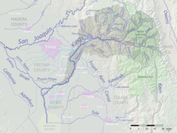 Map of the Kings River drainage basin. Bubbs Creek joins the South Fork at right. | |
Bubbs Creek is a 16.4-mile (26.4 km)-long tributary of the South Fork Kings River in the Sierra Nevada of California, within Kings Canyon National Park.
The creek originates near Junction Pass (east of Forester Pass), in northeastern Tulare County. It flows north through a chain of lakes and enters Fresno County, where it turns west, flowing in a deep glacial canyon. It joins the South Fork Kings River at the eastern end of Kings Canyon.
The Pacific Crest Trail follows Bubbs Creek from Forester Pass as far as Vidette Creek, and the Bubbs Creek Trail follows the creek downstream of that point into Kings Canyon.
Bubbs Creek is named for John Bubbs, a prospector who crossed into the drainage from Owens Valley via Kearsarge Pass in 1864.[3]
See also
References
- 1 2 "Bubbs Creek". Geographic Names Information System. United States Geological Survey. 1981-01-19. Retrieved 2018-05-21.
- 1 2 "National Hydrography Dataset via National Map Viewer". U.S. Geological Survey. Retrieved 2018-05-21.
- ↑ Farquhar, Francis P. "Place Names of the High Sierra (1926)". Yosemite Online. Retrieved 2018-05-21.
This article is issued from
Wikipedia.
The text is licensed under Creative Commons - Attribution - Sharealike.
Additional terms may apply for the media files.