Buan County
| Buan 부안군 | ||
|---|---|---|
| County | ||
| Korean transcription(s) | ||
| • Hangul | 부안군 | |
| • Hanja | 扶安郡 | |
| • Revised Romanization | Buan-gun | |
| • McCune-Reischauer | Puan-gun | |
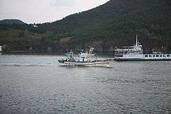 Byeonsan peninsula | ||
| ||
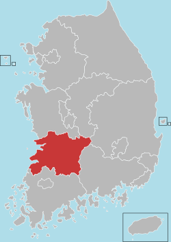
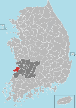 Location in South Korea | ||
| Country |
| |
| Region | Honam | |
| Administrative divisions | 1 eup, 12 myeon | |
| Area | ||
| • Total | 493.54 km2 (190.56 sq mi) | |
| Population (2013) | ||
| • Total | 59,164 | |
| • Density | 119.9/km2 (311/sq mi) | |
| • Dialect | Jeolla | |
Buan County (Buan-gun) is a county in North Jeolla Province, South Korea. It is bounded by the city of Jeongeup on the east, the county of Gochang on the south, the city of Gimje on the north, and Yellow Sea on the west. Buan is divided into 1 eup, 12 myeon, and 503 ri. Buan had a 2001 estimated population of 74,716 people and a 2013 population of 59,164 people with an area of 493.05㎢.[1] Famous people from Buan include Joseon Dynasty kisaeng and poet, Yi Mae-chang. Like many rural areas in southern Korea, it has seen shrinking population with many younger people moving north to larger cities such as Seoul. This county should not be confused with Muan, the NEW capital of South Jeolla Province.
Timeline
SAMHAN DYNASTY
During the Samhan Dynasry Buan County was called Mahan, and it was also called Jibang Land among the 54 Mahan lands. During the Bakjae Period there were two small localities : Gaehwa and Honliang.
SHILLA DYNASTY
In B.C 757(16th year of Kiong Gyeongdeok's regime), after Shilla united the three kingdoms, Gyehwa was renamed as Buryeong (sometimes called Gyebal) and was a part of Gobu. Honliang was renamed as Hee-an and was also a part of Gobu.
GORYEO DYNASTY
During the Gory대 the county was called Bo-an locality and was also nicknamed as Namju. In late Gory대, during King 쪄‘s regime, there were local governors were posted to Buryeong and Bo-an locality.
JOSEON DYNASTY
During year 14and 16 of king Taejong's regime, the two localities Buloung and Bo-an were merged and separated several times. Then in December 1416, the two localities were merged and was named Buan, the "bu" coming from Buryeong and the "an" coming from Bo-an. The following year a locality named Hongdeokjin was made a part of Buan and was renamed as Buanjin. A high-level civil servant named the Byongmasa ruled over the county. In 1423 (5th year of King Saejong's regime), the ruler was changed from Cheomjeoljesa to Hyeongam.Locality Buan was changed into Boan County in 1895 (32nd year of King Gojong's regime), when several different terms representing localities (bu, mok, gun, and hyeon) were unified to a single them- county. In 1914, during the Japanese occupation, the administrative district was changed: Wido become a part of Jeonnam Younggwang County, and Biando was annexed to Gunsan City. Bakshin, Kima, and Deoklim of Gobu County were annexed to Buan County.
1943
In 1943 Byreong-myeon was upgraded into Buan-dup. On January 1, 1963, 쨔애-myeon was annexed from Younggwang County to Bon County.
1963
According to changes in the administrative districts, Wido-myeon of Jeonnam Younggwang Country was annexed to Buan County.
1978
With the reclamation works of Gaehwado in 1978, the country's territory was increased by 3,968ha. In 1983 Sansomyun and Jinsomyun were divided into Gawhwa-myeon and Jinso-myeon.Currently, the administrative district consists of 1 eup and 13 myeon. The total area is 192.73㎢ (farming land 42%, forest land 42%, other 16%). Buan county is located and longitude 126 degrees 40 minutes, latitude 35 degrees 40 minutes. It is located to the west of Junlabukdo and its border meets with Gunsan City at the sea. To the north there is Gimje City, to the southeast there is Jeongeup City, and to the south there is Gochang County.The land is low in the east side and high on the west site. The peninsula sticks out on the Yellow Sea. To the southwest direction a mountain named Byeonsan stands in layers. To the northeast there are wide and rich fields. The coast line which runs from the mouth of the Dongjingang River to Julpo-myeon Oupo-ri, is 99 km long. The influence of sea winds bring about a lot of snow in the winter.
Climate
| Climate data for Buan (1981–2010, extremes 1969–present) | |||||||||||||
|---|---|---|---|---|---|---|---|---|---|---|---|---|---|
| Month | Jan | Feb | Mar | Apr | May | Jun | Jul | Aug | Sep | Oct | Nov | Dec | Year |
| Record high °C (°F) | 18.6 (65.5) |
21.1 (70) |
26.3 (79.3) |
30.9 (87.6) |
32.7 (90.9) |
33.2 (91.8) |
36.6 (97.9) |
36.6 (97.9) |
34.3 (93.7) |
29.5 (85.1) |
26.8 (80.2) |
18.5 (65.3) |
36.6 (97.9) |
| Average high °C (°F) | 4.1 (39.4) |
6.2 (43.2) |
11.2 (52.2) |
17.7 (63.9) |
22.8 (73) |
26.3 (79.3) |
29.4 (84.9) |
30.4 (86.7) |
26.3 (79.3) |
20.8 (69.4) |
13.8 (56.8) |
7.0 (44.6) |
18.0 (64.4) |
| Daily mean °C (°F) | −0.6 (30.9) |
1.2 (34.2) |
5.5 (41.9) |
11.3 (52.3) |
16.9 (62.4) |
21.3 (70.3) |
25.0 (77) |
25.6 (78.1) |
20.9 (69.6) |
14.6 (58.3) |
8.1 (46.6) |
2.0 (35.6) |
12.6 (54.7) |
| Average low °C (°F) | −5.0 (23) |
−3.3 (26.1) |
0.4 (32.7) |
5.7 (42.3) |
11.7 (53.1) |
17.2 (63) |
21.6 (70.9) |
21.8 (71.2) |
16.3 (61.3) |
9.0 (48.2) |
3.0 (37.4) |
−2.5 (27.5) |
8.0 (46.4) |
| Record low °C (°F) | −22.6 (−8.7) |
−18.7 (−1.7) |
−10.2 (13.6) |
−3.6 (25.5) |
2.5 (36.5) |
7.7 (45.9) |
13.8 (56.8) |
12.5 (54.5) |
4.9 (40.8) |
−2.2 (28) |
−9.8 (14.4) |
−20.2 (−4.4) |
−22.6 (−8.7) |
| Average precipitation mm (inches) | 34.3 (1.35) |
38.4 (1.512) |
48.9 (1.925) |
73.6 (2.898) |
89.0 (3.504) |
150.0 (5.906) |
276.0 (10.866) |
250.2 (9.85) |
146.9 (5.783) |
51.4 (2.024) |
53.9 (2.122) |
37.7 (1.484) |
1,250.4 (49.228) |
| Average precipitation days (≥ 0.1 mm) | 10.2 | 7.6 | 8.2 | 7.3 | 7.6 | 8.7 | 13.1 | 12.7 | 8.3 | 6.3 | 8.5 | 9.9 | 108.4 |
| Average snowy days | 8.8 | 5.9 | 1.6 | 0.1 | 0.0 | 0.0 | 0.0 | 0.0 | 0.0 | 0.1 | 2.2 | 6.6 | 25.2 |
| Average relative humidity (%) | 76.5 | 74.3 | 72.1 | 71.0 | 73.9 | 78.5 | 82.3 | 80.7 | 78.2 | 74.4 | 73.9 | 76.6 | 76.0 |
| Mean monthly sunshine hours | 165.0 | 178.6 | 217.1 | 240.3 | 253.4 | 219.0 | 203.6 | 227.5 | 215.9 | 223.9 | 169.5 | 153.7 | 2,472.9 |
| Percent possible sunshine | 53.0 | 58.2 | 58.6 | 61.2 | 58.2 | 50.2 | 45.9 | 54.4 | 58.0 | 64.0 | 54.8 | 50.7 | 55.6 |
| Source: Korea Meteorological Administration[2][3][4] (percent sunshine and snowy days)[5] | |||||||||||||
Transport
Buan Bus Terminal provides direct services to Seoul, Daejeon and Gwangju, as well as services within North Jeolla province to Jeonju, Gimje, Iksan, Gunsan, Jeongeup and Gochang. The nearest railway station is at Gimje on the Honam Line.
Major road
Tourist Attraction
- Eight Scenic Views of Byeonsan
- WoongYeonJoDae
- Jigso Waterfall
- SoSaMoJong
- WolMyeongMooAe
- SeoHaeNakJo (Glow of the Setting Sun on the West Sea)
- ChaeSeokBeomJu
- JiPoSinGyeong
- GaeAmGoJeok
- Museum
- New & Renewable Energy Village
- Seokjeong Literary Museum
- Hwimok Art Museum
Twin towns – sister cities
Buan is twinned with:
See also
References
- ↑ (in Korean) 부안군 Archived June 10, 2011, at the Wayback Machine. Nate / Encyclopedia of Korean Culture
- ↑ "평년값자료(1981–2010) 부안(243)" (in Korean). Korea Meteorological Administration. Retrieved 2011-05-07.
- ↑ "기후자료 극값(최대값) 전체년도 일최고기온 (℃) 최고순위, 부안(243)" (in Korean). Korea Meteorological Administration. Retrieved 25 February 2017.
- ↑ "기후자료 극값(최대값) 전체년도 일최저기온 (℃) 최고순위, 부안(243)" (in Korean). Korea Meteorological Administration. Retrieved 25 February 2017.
- ↑ "Climatological Normals of Korea" (PDF). Korea Meteorological Administration. 2011. p. 499 and 649. Archived from the original (PDF) on 7 December 2016. Retrieved 25 February 2017.
External links
| Wikimedia Commons has media related to Buan, Jeollabuk-do. |
Jeonju (capital) | ||||
 | Specific city |
| ||
| Cities | ||||
| Counties | ||||
Coordinates: 35°43′41″N 126°43′55″E / 35.7280555656°N 126.731944454°E