Brynamman
Brynamman
| |
|---|---|
 Brynamman Brynamman shown within Carmarthenshire | |
| Community | |
| Principal area | |
| Ceremonial county | |
| Country | Wales |
| Sovereign state | United Kingdom |
| Post town | AMMANFORD |
| Postcode district | SA18 |
| Dialling code | 01269 |
| Police | Dyfed-Powys |
| Fire | Mid and West Wales |
| Ambulance | Welsh |
| EU Parliament | Wales |
| UK Parliament | |
| Welsh Assembly | |
Brynamman (Welsh: Brynaman) is a village on the south side of the Black Mountain (Y Mynydd Du), part of the Brecon Beacons National Park (Parc Cenedlaethol Bannau Brycheiniog). The village is split into Upper Brynamman and Lower Brynamman by the River Amman, which is also the boundary between the counties of Carmarthenshire and Neath Port Talbot (in the old county of Glamorganshire). Ruins of stone dwellings (possibly prehistoric), an early type of lime kiln and rectangular medieval buildings found on the mountain show that people have lived in this area for a long time.
In the 18th century the Industrial Revolution, with iron and tin works and especially coal mining, transformed the area from a small, scattered farming community to a built-up, highly populated commercial centre. The Welsh language was at the fore and the successful participation in local and national eisteddfodau by numerous village people, choirs and bands put Brynamman on the map.
It was once a thriving village, with three bank branches on Station Road in Upper Brynamman alone. Today there are no industries in or around the village, its inhabitants having to commute to Ammanford, Swansea or Llanelli for work. The whole area has become more attractive to live in, with countryside and the wild open areas available for walking on the Black Mountain (Y Mynydd Du). It is still a stronghold of the Welsh language; children are taught the language at school, and it is spoken by the great majority of the local people.
Brynamman was previously known as Y Gwter Fawr (Welsh: "The Big Gutter"); the name was changed when the railway from Ammanford reached the village. The traveller and writer George Borrow describes aspects of Gwter Fawr in the mid-19th century in his book Wild Wales which was published in 1862. The current name is derived from "Brynamman House", the home of John Jones, builder of the railway.
Brynamman Golf Club (now defunct) first appeared in the mid 1920s. It continued into the 1930s.[1]
Treftadaeth Brynaman Heritage
Treftadaeth Brynaman Heritage known by its initials TBH, or Brynamman Heritage, is a well-established local history group based in the library of the Black Mountain Centre (old name Community Centre) in Upper Brynamman. The group has undertaken a number of local history projects; the results are regularly on show in a large display cabinet which shares a space with an art gallery all housed in the most important room in the building, the large open plan cafe. The group has only a small membership. For the Community Archives Wales project, the group are keen to research the changing nature of the shops and businesses in Brynamman, over the last century, and have a wide collection of photographs, billheads, letters and artefacts to digitise as well as interviews and stories from locals who remember those 'good old days'. At the height of prosperity, Upper and Lower Brynaman had over a hundred small shops and businesses as well as an iron foundry, two tinworks, brickworks all served by two railway companies, LMS and the GWR.
Ynys Dawela

Situated adjacent to the west of Brynamman, Ynys Dawela Nature Park nestles in the upper reaches of the Amman Valley. Its northern boundary is the Brecon Beacons National Park with the rugged backdrop of the Black Mountain whilst the river Amman, with its fringe of ancient oak woodland, forms its southern boundary. The park covers an area of 39 acres (15.8 hectares) and was once a working farm. The meadows dating from this period now support a rich assortment of flowers, some of which are scarce, like the Whorled Caraway and Meadow Thistle. The meadows are at their most beautiful in late summer when most of the flowers are in bloom.
The park has a range of important habitats supporting a diverse assemblage of plant and animal life. The wet grasslands, marshy ground and ponds are particularly important to amphibians, like newts, frogs and toads whose numbers are in decline throughout the world.
The site narrowly escaped opencast mining, before Dinefwr Borough Council secured its future by purchasing it from British Coal. Since then the park has been developed for quiet recreation and educational use. Its patchwork of meadows woods and wetlands, linked by a series of paths are now open for all to enjoy. The park is managed by Carmarthenshire County Council supported by volunteers from the Friends of Ynys Dawela.
Gallery of photos
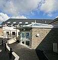 Black Mountain Centre in Brynamman
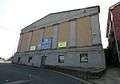 Brynamman Public Hall and Cinema
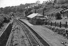 Former Brynamman GWR railway station in 1962
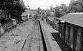 Former Brynamman LMS railway station in 1962
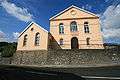 Gibea Chapel
Tregib Arms
The Tregib Arms is a public house in Brynamman built around 1860.
The first ever union branch to look after the needs of Welsh anthracite miners was started in the public bar in 1891. [2] The original certificate can be viewed in the lounge bar.
During the 1930s Welsh middleweight boxing champion Tommy Davies[3] was a regular customer; his photo can be seen in the main bar.
Notes
- ↑ "Brynamman Golf Club", "Golf’s Missing Links".
- ↑ The Society for the Protection of the Anthracite Miners Archived July 5, 2008, at the Wayback Machine.
- ↑ "Tommy Davies". Britishboxing.net. Archived from the original on 2012-07-11. Retrieved 2014-01-17.
External links
| Wikimedia Commons has media related to Brynamman. |