Brushy Butte
| Brushy Butte | |
|---|---|
 | |
| Highest point | |
| Elevation | 3,852 ft (1,174 m) [1] |
| Coordinates | 41°10′41″N 121°26′35″W / 41.178°N 121.443°WCoordinates: 41°10′41″N 121°26′35″W / 41.178°N 121.443°W [1] |
| Geography | |
| Location | Shasta County, California, U.S. |
| Parent range | Cascade Range |
| Geology | |
| Age of rock | Pleistocene |
| Mountain type | Shield volcano[1] |
| Volcanic arc | Cascade Volcanic Arc |
| Last eruption | Pleistocene |
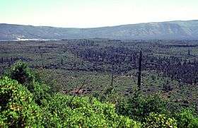
Brushy Butte is a small, poorly studied,[2] shield volcano located immediately east of Timbered Crater, south-southeast of the Medicine Lake Highlands in northern California, U.S. (near where Siskiyou County, California is adjacent to Shasta County, California).
See also
References
- 1 2 3 "Brushy Butte". Global Volcanism Program. Smithsonian Institution. Retrieved 2013-01-04.
- ↑ Harpel, Christopher J.; John W. Ewert (2000-10-05). "Bibliography of literature from 1990-1997 pertaining to Holocene and fumarolic Pleistocene volcanoes of Alaska, Canada, and the conterminous United States". Open-File Report 00-017, version 1.0. United States Geological Survey. Retrieved 2008-08-14.
This article is issued from
Wikipedia.
The text is licensed under Creative Commons - Attribution - Sharealike.
Additional terms may apply for the media files.