Brotjacklriegel
| Brotjacklriegel | |
|---|---|
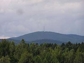 The mountain seen from the Rohrbach Reservoir | |
| Highest point | |
| Elevation | 1,011 m above sea level (NHN) (3,317 ft) |
| Prominence | 216 m ↓ [1] |
| Isolation | 17 km |
| Listing | Brotjacklriegel Transmitter, viewing tower |
| Coordinates | 48°49′1.23″N 13°13′3.12″E / 48.8170083°N 13.2175333°ECoordinates: 48°49′1.23″N 13°13′3.12″E / 48.8170083°N 13.2175333°E |
| Geography | |
 Brotjacklriegel | |
| Parent range | Bavarian Forest |
| Geology | |
| Type of rock | Gneiss |
Seen from the River Danube, the Brotjacklriegel is the first high mountain in the Bavarian Forest. It is 1,011 m above NHN[2] and lies in the county of Freyung-Grafenau in the German federal state of Bavaria. It is a symbol of the Sonnenwald region which comprises the municipalities of Schöfweg, Zenting, Innernzell, Grattersdorf and Market Schöllnach.
Name
According to legend, the Brotjacklriegel owes its name to a baker, Brotjackl, who is supposed to have hidden on the mountain during the Thirty Years' War. However, the name probably only came into being later during survey work by the French under Napoleon when because of a misunderstanding of the Bavarian "Broada Jaga-Riegel" (breiter Jägerriegel) the name Brotjacklriegel was written down.
History
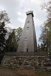
As early as 1839 the parish priest and two publicans from Langfurth built the first viewing tower. In 1924 the present 27-metre-high construction was built.
Description
On the eastern mountainside above Daxstein are overgrown clearance cairns.
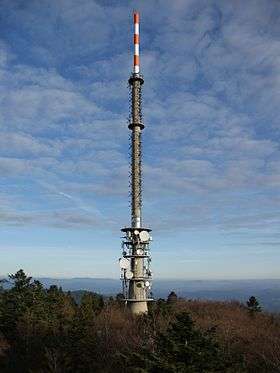
At the summit of the Brotjacklriegel is a TV and radio transmitter owned by the Bayerischer Rundfunk and a smaller viewing tower belonging to the Bavarian Forest Club.
Access
From the Jackl hikers' car park above the village of Langfurth to the top of the mountain runs a roughly two-kilometre-long trail, the Sonnenwald Nature Trail (Sonnenwald-Erlebnispfad ) with 10 stations at which the forest and its inhabitants are explained.[3]
References
- ↑ Isolation and prominence from Highrisepages.de at the Wayback Machine (archived October 19, 2014) (estimated value)
- ↑ Federal Office of Cartography and Geodesy, Landesamt für Vermessung und Geoinformation Bayern: digital topographical map 1:10,000 scale, BayernAtlas, retrieved 23 March 2014
- ↑ Nationalpark-FerienLand, Landratsamt Freyung-Grafenau zum Erlebnispfad, retrieved 4 June 2014
External links
| Wikimedia Commons has media related to Brotjacklriegel. |