Broomhill Bridge
| Broomhill Bridge | |
|---|---|
 | |
| Coordinates | 57°16′51″N 3°39′56″W / 57.280754°N 3.665426°WCoordinates: 57°16′51″N 3°39′56″W / 57.280754°N 3.665426°W |
| Carries | Unclassified public road (Station Road) |
| Crosses | River Spey |
| Characteristics | |
| Material | Wooden |
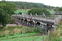
| No. of spans | 15 |
| History | |
| Engineering design by | John Mackenzie |
| Constructed by | Charles Mackay |
| Construction end | 1894 |
The Broomhill Bridge is a wooden bridge over the River Spey.
History
It was built by engineer John Mackenzie and contractor Charles Mackay, to replace a bridge that had been washed away.[1][2]
A plaque on the bridge states that the bridge was erected by the "Third, or Badenoch, District Committee of the Inverness-shire County Council," and that the last nail was driven by the Countess Dowager of Seafield on 27 November 1894.[3]
The bridge had to be partially rebuilt in 1987, when some trusses were replaced.[2][4] The Broomhill Bridge is of the same design as a bridge opened in 1899 at Boat of Garten, but this bridge has since been replaced.[5]
Design
The bridge has 15 wooden spans supported by trestle piers, and the five spans in the main river channel have triangular reinforcing trusses.[6] Each trestle consists of five posts, one vertical and two to each side of it at an angle.[2] Up to half-way up the pier it is reinforced by solid horizontal planking, and above that by diagonal beams on each side of the pier.[2] The five beams which support the roadway sit on a round-ended beam on top of each pier.[2] The abutments are granite,[1] and the piers have metal plates on their upstream faces to protect against debris.
It carries an unclassified public road known as Station Road.[7]
References
| Wikimedia Commons has media related to Broomhill Bridge. |
- 1 2 "BROOMHILL BRIDGE OVER RIVER SPEY (Ref:260)". Historic Scotland. Retrieved 1 January 2015.
- 1 2 3 4 5 "Broomhill Bridge". engineering-timelines.com. Retrieved 1 January 2015.
- ↑ Plaque on Bridge.
- ↑ Mettem, Christopher J. (2013). Timber Bridges. Routledge. p. 141. ISBN 978-1-135-72056-8.
- ↑ "Boat Of Garten, Garten Bridge, Old Garten Bridge And New Garten Bridge". canmore.rcahms.gov.uk. Retrieved 2 January 2015.
- ↑ "Broomhill Bridge". canmore.rcahms.gov.uk. Retrieved 1 January 2015.
- ↑ Google (2 January 2015). "Broomhill Bridge" (Map). Google Maps. Google. Retrieved 2 January 2015.