Bron
| Bron | ||
|---|---|---|
| Commune | ||
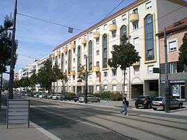 Buildings on the Avenue Franklin Roosevelt | ||
| ||
 Bron Location within Auvergne-Rhône-Alpes region  Bron | ||
| Coordinates: 45°44′22″N 4°54′50″E / 45.7394°N 4.9139°ECoordinates: 45°44′22″N 4°54′50″E / 45.7394°N 4.9139°E | ||
| Country | France | |
| Region | Auvergne-Rhône-Alpes | |
| Metropolis | Metropolis of Lyon | |
| Arrondissement | Lyon | |
| Government | ||
| • Mayor (2015-2020) | Jean-Michel Longueval (PS) | |
| Area1 | 10.3 km2 (4.0 sq mi) | |
| Population (2012)2 | 39,232 | |
| • Density | 3,800/km2 (9,900/sq mi) | |
| Time zone | UTC+1 (CET) | |
| • Summer (DST) | UTC+2 (CEST) | |
| INSEE/Postal code | 69029 /69500 | |
| Elevation |
183–221 m (600–725 ft) (avg. 212 m or 696 ft) | |
|
1 French Land Register data, which excludes lakes, ponds, glaciers > 1 km2 (0.386 sq mi or 247 acres) and river estuaries. 2 Population without double counting: residents of multiple communes (e.g., students and military personnel) only counted once. | ||
.svg.png)
Bron is a commune in the Metropolis of Lyon in Auvergne-Rhône-Alpes region in eastern France.
Geography
It lies 10 km (6.2 mi) east of Lyon. It is the sixth-largest suburb of the city of Lyon, and is adjacent to its east side.
History
The earliest traces of life in Bron can be found in the cemetery and date from 71 BC. The town as it is today did not take shape until approximately 1812.
In mid-August 1944, prisoners from Montluc prison were taken to Bron Airfield where 109 of them, including 72 Jews, were killed in what would become known as Le Charnier de Bron ("The Charnel house of Bron").[1]
Bron was spared much of the damage caused by the riots in many of France's suburbs in the 1990s, such as in Venissieux and Villeurbanne.
Sights
Bron has a fort (erected between 1872 and 1876).
Transport
Bron is served by the following TCL (Lyon public transport) services:
- Metro
- Line D (Gare de Vaise to Gare de Vénissieux) – served by 2 stations (Mermoz-Pinel and Parilly) located on the boundary with Lyon.
- Tram
- Line T2 (Perrache to Saint-Priest Bel-Air) – served by 8 stations.
- Line T5 (Grange-Blanche to Parc du Chêne, continuing to Eurexpo on exhibition days) – served by 7 stations.
- Bus
- C8 (Grange Blanche - Vaulx-en-Velin Résistance)
- C9 (Bellecour Antoine Poncet - Hôpitaux Est)
- C15 (Laurent Bonnevay - Bachut Mairie du 8e)
- C17 (Charpennes - Laurent Bonnevay)
- 24 (Bachut – Bron – Sept Chemins)
- 25 (Cordeliers – Gare Part-Dieu – Montchat – Sept Chemins)
- 26 (Bachut – Bron Aéroport – Manissieux)
- 52 (Parilly Université Hippodrome - Vaulx-En-Velin La Grappinière)
- 64 (Laurent Bonnevay – La Soie – Bron Droits de l'Homme)
- 68 (Vaulx-en-Velin La Soie – Chassieu – Azieu)
- 78 (Mermoz-Pinel – Parc du Chêne – Sept Chemins)
- 79 (Grange Blanche – Bron – Décines or Chassieu)
- 81 (Laurent Bonnevay – Bron – Porte des Alpes)
- 82 (Vaulx-en-Velin La Soie – Bron – La Borelle)
- 93 (Hôpital Feyzin Vénissieux - Porte des Alpes / Parc Technologique)
- Zi7 (Vaulx-En-Velin La Soie - Bron Droits De L'Homme)
Bron airport
Lyon-Bron Airport (technically located in the communes of Chassieu and Saint-Priest) has existed since 1920, although much of its commercial activity was diverted to Satolas (Saint-Exupéry International Airport), Lyon's main airport, in 1975.
Education
Bron is home to part of the University of Lyon 2. The Bron campus is located on the south-eastern edge of the town, close to the Parc de Parilly and Saint-Priest.
Twin towns
Bron is twinned with:
See also
References
- ↑ "Bron: le panneau en mémoire des charniers de l'aéroport dévoilé" [Bron: memorial unveiled to mass graves at the airport]. Le Progrès. 2 September 2014. Retrieved 28 April 2015.
External links
| Wikimedia Commons has media related to Bron. |
- Official website
- History of Bron (in French)