Brockley Whins Metro station
| Brockley Whins | |
|---|---|
| Tyne & Wear Metro | |
|
| |
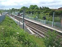
.jpg) Brockley Whins station in 2012 | |
| Location | |
| Place | Brockley Whins |
| Local authority | South Tyneside |
| WGS84 | 54°57′34″N 1°27′39″W / 54.9595°N 1.4609°WCoordinates: 54°57′34″N 1°27′39″W / 54.9595°N 1.4609°W |
| Fare zone information | |
| Network One zone | 3 |
| Metro zone | B |
| Original (1979) zone | 37 |
| Station code | BNR |
| Usage | |
| Metro Usage | 0.23[1] million |
| History | |
| Opened | June 1839 |
| Metro since | 31 March 2002 |
| List of stations | |
Brockley Whins Metro station is on the Tyne and Wear Metro's Green Line. It serves the Brockley Whins area of South Shields as well as northern Boldon Colliery, both in South Tyneside.
The station was formerly served by mainline services between Sunderland and Newcastle, but was taken over by the Metro as part of the extension to Sunderland and South Hylton in 2002. Today the services operated by the current franchise holder Northern pass through the station but do not stop, along with empty Grand Central workings between Heaton TMD and Sunderland. Some freight trains (mainly carrying imported coal) also approach the station en route to the deep water terminal at the Port of Tyne, which is accessed via the branch line that diverges just to the west.
History
The original 1839 Brockley Whins station, on the Brandling Junction Railway (BJR), only had a platform on the down line (towards Newcastle). This meant trains towards Sunderland had to cross over onto the opposite track to allow passengers to board and alight (an arrangement quite common on other railways in the area, e.g. Crook). This arrangement resulted in an accident causing five deaths on 6 December 1870; the subsequent investigation led to changes in the law, as well as the construction of a second platform to the east of the existing one to serve Sunderland-bound trains.[2] When the station was converted for Metro use, the westbound platform was relocated opposite the newer eastbound one.
The station was originally a busy junction, as the former Stanhope and Tyne Railway route from Tyne Dock to Consett and Waskerley via Washington crossed the BJR on the level just to the east of the station at Pontop Crossing, with various curves being laid in to connect the two routes. Since the 1850s passenger traffic has only taken place on the present east–west route, although the old north–south line was used by freight traffic as late as 1966.[3][4] The station was renamed as Boldon Colliery by the London and North Eastern Railway from 1 March 1925, but reverted to its original name in July 1991.[3]
Services
Trains towards South Hylton via Sunderland, and towards Airport via Gateshead and Newcastle serve the station roughly every 12 minutes throughout the day, and every 15 minutes on Sundays.[5].
Although no direct bus interchange is provided, bus stops served by Go North East and Stagecoach for services towards South Shields town centre and Newcastle, can be found in the housing estates to the north.
The station has storage for 10 bicycles, but no car parking spaces.[5]
References
- ↑ "Automated Announcements / Track Map / Usage Statistics". 2015–2016. Retrieved 29 April 2017.
- ↑ Rolt, L.T.C. (1955). Red for Danger: The Classic History of British Railway Disasters. pp. 61–63.
- 1 2 ""Disused Stations - Brockley Whins Station (2nd site)"". "Disused Stations". Retrieved 9 July 2018.
- ↑ ""Disused Stations - Boldon Station"". "Disused Stations". Retrieved 9 July 2018.
- 1 2 "Brockley Whins - Nexus Tyne & Wear". Nexus. Retrieved 9 July 2018.
| Wikimedia Commons has media related to Brockley Whins Metro station. |
External links
- Report of the Board of Trade enquiry into the 1870 accident.
| Preceding station | Tyne and Wear Metro | Following station | ||
|---|---|---|---|---|
towards Airport | Green line | towards South Hylton |